NASA satellite reveals a depressed and disorganized Henri
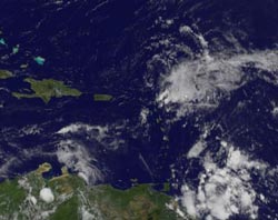
NASA\'s GOES Project created an image of Tropical Depression Henri (top right) using data from the GOES-12 satellite on Oct. 8 at 10:45 a.m. EDT. The image shows Henri as a disorganized area of clouds, located east of the Leeward Islands (the chain of islands left of Henri, running north to south). Puerto Rico and Hispaniola lit to Henri\'s west. Credit: NASA GOES Project<br>
At 11 a.m. EDT on October 8, Henri's maximum sustained winds were down to 35 mph and waning. The National Hurricane Center used NASA's QuikScat satellite wind date from 6:12 a.m. EDT this morning to confirm Henri's wind speed.
His center was located 130 miles north-northeast of the northern Leeward Islands, near latitude 19.8 North and longitude 62.0 West. Tropical Depression Henri is moving toward the west near 13 mph and he's expected to slow down in the next day. Minimum central pressure is near 1010 millibars.
The Geostationary Operational Environmental Satellite known as GOES-12 covers the Atlantic Ocean, and is managed by the National Oceanic and Atmospheric Administration (NOAA). NASA's GOES Project, located at NASA's Goddard Space Flight Center, Greenbelt, Md. creates some of the GOES satellite images. An image created on October 8 at 10:45 a.m. EDT showed Henri as a disorganized area of cloudiness, located east of the Leeward Islands.
While on his westward track, Henri is expected to produce between 1 and 2 inches of rainfall over the northern Leeward Islands and the Virgin Islands.
Henri is likely to degenerate into a remnant low later today because he's in an environment of battering winds. Henri will remain in an environment of strong southwesterly shear today, and later winds from the northeast will hammer away at him, further weakening his circulation.
Media Contact
More Information:
http://www.nasa.govAll latest news from the category: Earth Sciences
Earth Sciences (also referred to as Geosciences), which deals with basic issues surrounding our planet, plays a vital role in the area of energy and raw materials supply.
Earth Sciences comprises subjects such as geology, geography, geological informatics, paleontology, mineralogy, petrography, crystallography, geophysics, geodesy, glaciology, cartography, photogrammetry, meteorology and seismology, early-warning systems, earthquake research and polar research.


Newest articles

High-energy-density aqueous battery based on halogen multi-electron transfer
Traditional non-aqueous lithium-ion batteries have a high energy density, but their safety is compromised due to the flammable organic electrolytes they utilize. Aqueous batteries use water as the solvent for…

First-ever combined heart pump and pig kidney transplant
…gives new hope to patient with terminal illness. Surgeons at NYU Langone Health performed the first-ever combined mechanical heart pump and gene-edited pig kidney transplant surgery in a 54-year-old woman…

Biophysics: Testing how well biomarkers work
LMU researchers have developed a method to determine how reliably target proteins can be labeled using super-resolution fluorescence microscopy. Modern microscopy techniques make it possible to examine the inner workings…

