More than 100 years of flooding and erosion in 1 event
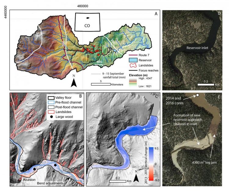
Flood impacts in the North St. Vrain Creek catchment, northern Colorado, USA. Images in D and E are from Google Earth™
More than half of the eroded sediment was deposited at the inlet and delta of a water supply reservoir, resulting in the equivalent of 100 years of reservoir sedimentation and 2% loss in water storage capacity.
The flood discharged 28 mega-grams of carbon from one square kilometer of land (28 Mg C/km2), which is more like what would happen in humid, tectonically active areas.
To get an idea of what that means, Rathburn explains, a mega-gram of carbon (C) eroded from one square kilometer of land is equivalent to about a million paper clips covering an 18-hole golf course. So in this scenario, the flood discharged 28 million paper clips from just a golf course-sized area.
Post-flood remobilization resulted in a further ~100-years-worth of reservoir sedimentation plus export of an additional 1.3 mega-grams of carbon per square kilometer (1.3 Mg C/km2) of wood. Pronounced channel widening during the flood created accommodation space for 40% of flood sediment and storage of wood and eroded carbon. Confined channels, normally dismissed as transport reaches, can store and export substantial amounts of flood constituents.
The results of this study by Rathburn and colleagues indicate that many flood-affected Colorado Front Range rivers will export sediment, wood, and carbon for years to come, posing ongoing challenges for water-supply management, with implications for terrestrial carbon cycling.
###
ARTICLE
The fate of sediment, wood and organic carbon eroded during an extreme flood, Colorado Front Range, USA http://geology.
Authors: S.L Rathburn, G.L. Bennett, E.E. Wohl, C. Briles, B. McElroy, and N. Sutfin. Contact: Sara Rathburn, Colorado State University, Fort Collins, Colorado, USA, sara.rathburn@colostate.edu.
GEOLOGY articles are online http://geology.
Media Contact
All latest news from the category: Earth Sciences
Earth Sciences (also referred to as Geosciences), which deals with basic issues surrounding our planet, plays a vital role in the area of energy and raw materials supply.
Earth Sciences comprises subjects such as geology, geography, geological informatics, paleontology, mineralogy, petrography, crystallography, geophysics, geodesy, glaciology, cartography, photogrammetry, meteorology and seismology, early-warning systems, earthquake research and polar research.


Newest articles

A universal framework for spatial biology
SpatialData is a freely accessible tool to unify and integrate data from different omics technologies accounting for spatial information, which can provide holistic insights into health and disease. Biological processes…

How complex biological processes arise
A $20 million grant from the U.S. National Science Foundation (NSF) will support the establishment and operation of the National Synthesis Center for Emergence in the Molecular and Cellular Sciences (NCEMS) at…

Airborne single-photon lidar system achieves high-resolution 3D imaging
Compact, low-power system opens doors for photon-efficient drone and satellite-based environmental monitoring and mapping. Researchers have developed a compact and lightweight single-photon airborne lidar system that can acquire high-resolution 3D…

