Arctic Sea Ice Shrinks To New Low In Satellite Era
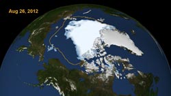
This visualization shows the extent of Arctic sea ice on Aug. 26, 2012, the day the sea ice dipped to its smallest extent ever recorded in more than three decades of satellite measurements, according to scientists from NASA and the National Snow and Ice Data Center. The data is from the U.S. Defense Meteorological Satellite Program’s Special Sensor Microwave/Imager. The line on the image shows the average minimum extent from the period covering 1979-2010, as measured by satellites. Every summer the Arctic ice cap melts down to what scientists call its “minimum” before colder weather builds the ice cover back up. The size of this minimum remains in a long-term decline. The extent on Aug. 26. 2012 broke the previous record set on Sept. 18, 2007. But the 2012 melt season could still continue for several weeks. Image credit: Scientific Visualization Studio, NASA Goddard Space Flight Center <br>
The extent of Arctic sea ice on Aug. 26, as measured by the Special Sensor Microwave/Imager on the U.S. Defense Meteorological Satellite Program spacecraft and analyzed by NASA and NSIDC scientists, was 1.58 million square miles (4.1 million square kilometers), or 27,000 square miles (70,000 square kilometers) below the Sept. 18, 2007, daily extent of 1.61 million square miles (4.17 million square kilometers).
The sea ice cap naturally grows during the cold Arctic winters and shrinks when temperatures climb in the spring and summer. But over the last three decades, satellites have observed a 13 percent decline per decade in the minimum summertime extent of the sea ice. The thickness of the sea ice cover also continues to decline.
“The persistent loss of perennial ice cover — ice that survives the melt season — led to this year's record summertime retreat,” said Joey Comiso, senior research scientist at NASA's Goddard Space Flight Center in Greenbelt, Md. “Unlike 2007, temperatures were not unusually warm in the Arctic this summer.”
The new record was reached before the end of the melt season in the Arctic, which usually takes place in mid- to late-September. Scientists expect to see an even larger loss of sea ice in the coming weeks.
“In 2007, it was actually much warmer,” Comiso said. “We are losing the thick component of the ice cover. And if you lose the thick component of the ice cover, the ice in the summer becomes very vulnerable.”
“By itself it's just a number, and occasionally records are going to get set,” NSIDC research scientist Walt Meier said about the new record. “But in the context of what's happened in the last several years and throughout the satellite record, it's an indication that the Arctic sea ice cover is fundamentally changing.”
For images, video and background on sea ice, go to:
http://svs.gsfc.nasa.gov/Gallery/ArcticSeaIceResources.html
For National Snow and Ice Data Center information on Arctic Sea Ice, go to:
http://nsidc.org/arcticseaicenews/
Maria-Jose Vinas
Goddard Space Flight Center, Greenbelt, Md.
Media Contact
All latest news from the category: Life Sciences and Chemistry
Articles and reports from the Life Sciences and chemistry area deal with applied and basic research into modern biology, chemistry and human medicine.
Valuable information can be found on a range of life sciences fields including bacteriology, biochemistry, bionics, bioinformatics, biophysics, biotechnology, genetics, geobotany, human biology, marine biology, microbiology, molecular biology, cellular biology, zoology, bioinorganic chemistry, microchemistry and environmental chemistry.


Newest articles

A universal framework for spatial biology
SpatialData is a freely accessible tool to unify and integrate data from different omics technologies accounting for spatial information, which can provide holistic insights into health and disease. Biological processes…

How complex biological processes arise
A $20 million grant from the U.S. National Science Foundation (NSF) will support the establishment and operation of the National Synthesis Center for Emergence in the Molecular and Cellular Sciences (NCEMS) at…

Airborne single-photon lidar system achieves high-resolution 3D imaging
Compact, low-power system opens doors for photon-efficient drone and satellite-based environmental monitoring and mapping. Researchers have developed a compact and lightweight single-photon airborne lidar system that can acquire high-resolution 3D…

