NASA Sees Typhoon Francisco Headed to the Other Side of Guam
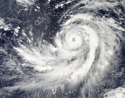
NASA's Aqua satellite captured this image of Typhoon Francisco on Oct. 17 at 04:05 UTC in the Pacific Ocean as it started turning to the northwest after passing Guam. <br>Image Credit: NASA Goddard MODIS Rapid Response Team <br>
The Moderate Resolution Imaging Spectroradiometer instrument aboard NASA's Aqua satellite captured an image of Typhoon Francisco on Oct. 17 at 04:05 UTC in the Pacific Ocean as it started turning to the northwest after passing the eastern side Guam. The MODIS image clearly showed Francisco's eye, indicating its strength and organization.
On Oct. 17 at 1500 UTC/11 a.m. EDT Francisco had maximum sustained winds near 85 knots and was moving to the north-northeast, but is expected to take a turn to the northwest. Francisco's center was located about 147 nautical miles southwest of Guam, near 12.5 north and 143.1 east.
On Oct. 17 and 18 (local time), a Tropical Storm Warning was in effect for Guam. The National Weather Service bulletin on Oct. 17 at 3 p.m. EDT noted: as Typhoon Francisco (26w) passes…sustained tropical storm force winds are expected. Maximum winds are still forecast to be in the 30 to 40 mph range with gusts to 60 mph. Minor damage may occur to poorly constructed homes. Isolated power outages will be possible. Choppy seas of 12 to 14 feet will persist through tonight.
Text credit: Rob Gutro
NASA's Goddard Space Flight Center
Media Contact
All latest news from the category: Earth Sciences
Earth Sciences (also referred to as Geosciences), which deals with basic issues surrounding our planet, plays a vital role in the area of energy and raw materials supply.
Earth Sciences comprises subjects such as geology, geography, geological informatics, paleontology, mineralogy, petrography, crystallography, geophysics, geodesy, glaciology, cartography, photogrammetry, meteorology and seismology, early-warning systems, earthquake research and polar research.


Newest articles

A universal framework for spatial biology
SpatialData is a freely accessible tool to unify and integrate data from different omics technologies accounting for spatial information, which can provide holistic insights into health and disease. Biological processes…

How complex biological processes arise
A $20 million grant from the U.S. National Science Foundation (NSF) will support the establishment and operation of the National Synthesis Center for Emergence in the Molecular and Cellular Sciences (NCEMS) at…

Airborne single-photon lidar system achieves high-resolution 3D imaging
Compact, low-power system opens doors for photon-efficient drone and satellite-based environmental monitoring and mapping. Researchers have developed a compact and lightweight single-photon airborne lidar system that can acquire high-resolution 3D…

