NASA Sees Tropical Storm Pewa Temporarily Weaken
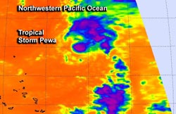
NASA's Aqua satellite captured this infrared image of Tropical Storm Pewa (purple) on Aug. 20 at 01:47 UTC/9:47 p.m. EDT, Aug. 19 as it weakened. Coldest cloud top temperatures and strongest storms appear in purple. Image Credit: <br>NASA/JPL, Ed Olsen<br>
The Atmospheric Infrared Sounder or AIRS instrument aboard NASA's Aqua satellite captured an infrared image of Tropical Storm Pewa on Aug. 20 at 01:47 UTC/9:47 p.m. EDT, Aug. 19 as it weakened.
The coldest cloud top temperatures and strongest storms were confined to a small area around the storm's center and in a band of thunderstorms northeast of the center.
Cloud top temperatures in both of those areas were as cold as -63F/-52C. Infrared imagery since this AIRS image has shown that convection has deepened and thunderstorms have become stronger.
At 0900 UTC on Aug. 20, Pewa's maximum sustained winds dropped to 45 knots/51.7 mph/83.3 kph as it faced wind shear. By 1500 UTC/11 a.m. EDT, winds had strengthened to 50 knots/57.5 mph/92.6 kph. Forecasters at the Joint Typhoon Warning Center expect Pewa to strengthen into a typhoon later this week. Pewa was located near 17.5 north and 173.4 east, about 436 nautical miles east-southeast of Wake Island. Pewa is moving to the northwest at 13 knots/15 mph/24 kph and is expected to pass far to the north of Wake Island from Aug. 21 to 22.
Forecasters at the Joint Typhoon Warning Center noted that as Pewa moves through warm ocean waters, a decrease in vertical wind shear will happen over the next couple of days and that will allow for Pewa to strengthen to typhoon force.
Text credit: Rob Gutro
NASA's Goddard Space Flight Center
Media Contact
All latest news from the category: Earth Sciences
Earth Sciences (also referred to as Geosciences), which deals with basic issues surrounding our planet, plays a vital role in the area of energy and raw materials supply.
Earth Sciences comprises subjects such as geology, geography, geological informatics, paleontology, mineralogy, petrography, crystallography, geophysics, geodesy, glaciology, cartography, photogrammetry, meteorology and seismology, early-warning systems, earthquake research and polar research.


Newest articles

High-energy-density aqueous battery based on halogen multi-electron transfer
Traditional non-aqueous lithium-ion batteries have a high energy density, but their safety is compromised due to the flammable organic electrolytes they utilize. Aqueous batteries use water as the solvent for…

First-ever combined heart pump and pig kidney transplant
…gives new hope to patient with terminal illness. Surgeons at NYU Langone Health performed the first-ever combined mechanical heart pump and gene-edited pig kidney transplant surgery in a 54-year-old woman…

Biophysics: Testing how well biomarkers work
LMU researchers have developed a method to determine how reliably target proteins can be labeled using super-resolution fluorescence microscopy. Modern microscopy techniques make it possible to examine the inner workings…

