NASA sees pinhole eye seen in weakening Tropical Cyclone Winston
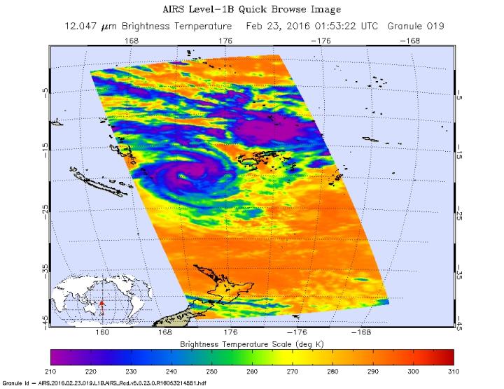
On Feb. 23, 2016 at 01:53 UTC (Feb. 22 at 8:53 p.m. EST), the AIRS instrument aboard NASA's Aqua satellite saw some cloud top temperatures in Tropical Cyclone Winston were colder than -63F/-53C (purple), indicating they were high into the troposphere. Credit: NASA JPL, Ed Olsen
On Feb. 23, 2016 at 0140 UTC (Feb. 22, 2016 at 8:40 p.m. EST) the Visible Infrared Imaging Radiometer Suite (VIIRS) instrument aboard NASA-NOAA's Suomi NPP satellite captured a visible image of Tropical Cyclone Winston that showed a pinhole eye as it was moving east of Vanuatu's southernmost islands.
Animated enhanced infrared satellite imagery indicated a slowly-decaying low-level circulation center with curved strong bands of thunderstorms wrapping into the center of the storm.
The Atmospheric Infrared Sounder or AIRS instrument that flies aboard NASA's Aqua satellite provided infrared temperature data on the system on Feb. 23, 2016 at 01:53 UTC (Feb. 22, 2016 at 8:53 p.m. EST).
Some cloud top temperatures were colder than minus 63 Fahrenheit/ minus 53 Celsius, indicating they were high into the troposphere. Cloud top temperatures that cold have shown that those storms can produce heavy rainfall
Joint Typhoon Warning Center (JTWC) said that at 1500 GMT (10 a.m. EST) Winston's maximum sustained winds dropped to 70 knots (80.5 mph/129.6 kph) making it a Category 1 hurricane.
It was located about 303 nautical miles (348 miles/561.2 km) west-southwest of Suva, Fiji near 20.7 degrees south latitude and 173.8 degrees east longitude. Winston had increased in forward speed since Feb. 22, 2016 and was moving to the south-southeast to 9 knots (10.3 mph/16.6 kph).
JTWC forecasters expect that Winston will turn southwestward to west-southwestward on Feb. 24, 2016 as it transitions to the steering influence of a building sub-tropical ridge (elongated area of high pressure) to the south. Tc 11p is expected to weaken significantly after Feb. 24, 2016 as it encounters strong vertical wind shear and cooler sea surface temperatures.
Media Contact
All latest news from the category: Earth Sciences
Earth Sciences (also referred to as Geosciences), which deals with basic issues surrounding our planet, plays a vital role in the area of energy and raw materials supply.
Earth Sciences comprises subjects such as geology, geography, geological informatics, paleontology, mineralogy, petrography, crystallography, geophysics, geodesy, glaciology, cartography, photogrammetry, meteorology and seismology, early-warning systems, earthquake research and polar research.


Newest articles

High-energy-density aqueous battery based on halogen multi-electron transfer
Traditional non-aqueous lithium-ion batteries have a high energy density, but their safety is compromised due to the flammable organic electrolytes they utilize. Aqueous batteries use water as the solvent for…

First-ever combined heart pump and pig kidney transplant
…gives new hope to patient with terminal illness. Surgeons at NYU Langone Health performed the first-ever combined mechanical heart pump and gene-edited pig kidney transplant surgery in a 54-year-old woman…

Biophysics: Testing how well biomarkers work
LMU researchers have developed a method to determine how reliably target proteins can be labeled using super-resolution fluorescence microscopy. Modern microscopy techniques make it possible to examine the inner workings…

