NASA Sees Emilia as a Category 2 Hurricane Now
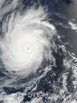
NASA's Aqua satellite captured this visible image of Hurricane Emilia on July 10, 2012 at 2035 UTC / 4:35 p.m. EDT. Credit: NASA MODIS Rapid Response Team <br>
The Moderate Resolution Imaging Spectroradiometer (MODIS) instrument that flies onboard NASA's Aqua satellite captured a visible image of Hurricane Emilia on July 10, 2012 at 2035 UTC / 4:35 p.m. EDT when its winds had weakened down to 125 mph (205 kmh). Emilia continued weakening after Aqua passed by.
On July 11 at 5 a.m. EDT, Emilia's maximum sustained winds were near 105 mph (165 kmh) and is now a Category 2 hurricane on the Saffir-Simpson scale. Emilia is over 210 miles (330 km) in diameter, which is the extent of its tropical-storm-force winds. On July 11 the Atmospheric Infrared Sounder (AIRS) data from NASA's Aqua satellite showed that cloud top temperatures around Emilia's eye were still as cold as -94 Fahrenheit (-70 Celsius) indicating the eye is still surrounded by powerful thunderstorms.
Emilia was located about 720 miles (1160 km) southwest of the southern tip of Baja California. Emilia is moving at 10 mph (17 kmh) to the west-northwest. Emilia is expected to continue moving in the same direction because it is skirting the southern edge of a subtropical ridge (elongated area) of high pressure (which rotates clockwise), located to its north.
The National Hurricane Center expects Emilia to continue on a weakening trend as it moves over cooler waters and runs into drier and more stable air as wind shear increases.
For larger image, visit: http://lance-modis.eosdis.nasa.gov/cgi-bin/imagery/single.cgi?image=Emilia.A2012192.2035.250m.jpg.
Text Credit: Rob Gutro
NASA's Goddard Space Flight CenterGreenbelt, Md.
Media Contact
All latest news from the category: Earth Sciences
Earth Sciences (also referred to as Geosciences), which deals with basic issues surrounding our planet, plays a vital role in the area of energy and raw materials supply.
Earth Sciences comprises subjects such as geology, geography, geological informatics, paleontology, mineralogy, petrography, crystallography, geophysics, geodesy, glaciology, cartography, photogrammetry, meteorology and seismology, early-warning systems, earthquake research and polar research.


Newest articles

A universal framework for spatial biology
SpatialData is a freely accessible tool to unify and integrate data from different omics technologies accounting for spatial information, which can provide holistic insights into health and disease. Biological processes…

How complex biological processes arise
A $20 million grant from the U.S. National Science Foundation (NSF) will support the establishment and operation of the National Synthesis Center for Emergence in the Molecular and Cellular Sciences (NCEMS) at…

Airborne single-photon lidar system achieves high-resolution 3D imaging
Compact, low-power system opens doors for photon-efficient drone and satellite-based environmental monitoring and mapping. Researchers have developed a compact and lightweight single-photon airborne lidar system that can acquire high-resolution 3D…

