Two satellites see newborn Tropical Storm Jimena consolidating
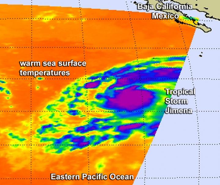
This false-colored infrared image from Aug. 27 at 09:47 UTC (4:57 a.m. EDT) shows high, cold, strong thunderstorms (purple) with cloud top temperatures in excess of -63F/-53C around the center of Tropical Storm Jimena. Credits: NASA JPL, Ed Olsen
Tropical Depression 13E formed about 865 miles (1,390 km) south-southwest of the southern tip of Baja California, Mexico at 5 p.m. EDT (2100 UTC) on August 26. Six hours later, the depression strengthened into Tropical Storm Jimena at 11 p.m. EDT.
A false-colored infrared image from Aug. 27 at 09:47 UTC (4:57 a.m. EDT) showed high, cold, strong thunderstorms surrounding the center of Tropical Storm Jimena. AIRS imagery also showed a thick band of thunderstorms spiraling into the northern quadrant of the storm from the east.
Coldest cloud top temperatures were as cold as -63F/-53C around the center of the tropical storm. NASA research has shown that thunderstorms with cloud tops that cold and high in the troposphere have the potential to generate heavy rainfall.
At 11 a.m. EDT on August 27, Forecaster Berg of the National Hurricane Center noted that Jimena is steadily becoming better organized with deep convection persisting near the center and more pronounced banding developing around the circulation.
NOAA's GOES-West satellite captured imagery of Tropical Storm Jimena's clouds at 8 a.m. EDT on Aug. 27. The image showed a tight circular area of thunderstorms around the center of circulation and bands of thunderstorms from the northern and southern quadrants wrapping into the center.
On August 27 at 11 a.m. EDT (8 a.m. PDT/1500 UTC), the center of Tropical Storm Jimena was located near latitude 12.4 North, longitude 117.7 West. That's about 890 miles (1,430 km) southwest of the southern tip of Baja California, Mexico. Jimena was moving toward the west-northwest near 17 mph and is expected to turn west and slow down later in the day. Maximum sustained winds had increased to near 45 mph (75 kph). The estimated minimum central pressure is 1003 millibars.
Berg's forecast discussion noted that “rapid intensification is a distinct possibility during the next 24 hours.” Jimena is forecast to become a hurricane on August 27.
Media Contact
All latest news from the category: Earth Sciences
Earth Sciences (also referred to as Geosciences), which deals with basic issues surrounding our planet, plays a vital role in the area of energy and raw materials supply.
Earth Sciences comprises subjects such as geology, geography, geological informatics, paleontology, mineralogy, petrography, crystallography, geophysics, geodesy, glaciology, cartography, photogrammetry, meteorology and seismology, early-warning systems, earthquake research and polar research.


Newest articles

A universal framework for spatial biology
SpatialData is a freely accessible tool to unify and integrate data from different omics technologies accounting for spatial information, which can provide holistic insights into health and disease. Biological processes…

How complex biological processes arise
A $20 million grant from the U.S. National Science Foundation (NSF) will support the establishment and operation of the National Synthesis Center for Emergence in the Molecular and Cellular Sciences (NCEMS) at…

Airborne single-photon lidar system achieves high-resolution 3D imaging
Compact, low-power system opens doors for photon-efficient drone and satellite-based environmental monitoring and mapping. Researchers have developed a compact and lightweight single-photon airborne lidar system that can acquire high-resolution 3D…

