Satellite sees Flossie fizzle fast
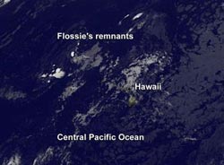
NOAA's GOES-15 satellite captured infrared imagery of the remnants of what was Tropical Depression Flossie northwest of Niihau and Kauai in the Hawaiian Island chain.<br><br>Credit: NASA GOES Project<br>
NOAA's Central Pacific Hurricane Center issued the final advisory on the remnants of Tropical Depression Flossie on July 30 at 1500 UTC/11 a.m. EDT.
At that time Flossie's remnant low pressure area was centered near 22.3 north latitude and 159.8 west longitude, about 140 miles west-northwest of Honolulu, Hawaii. The low pressure area was still moving to the west-northwest at 16 knots and the maximum sustained winds had dropped to 25 knots.
On July 31 at 1500 UTC (11 a.m. EDT) NOAA's GOES-15 or GOES-West satellite captured infrared imagery of the remnants of what was Tropical Depression Flossie northwest of Niihau and Kauai in the Hawaiian Island chain.
The remnant clouds appear scattered and almost ghost-like on the infrared satellite imagery. The image was created by NASA's GOES Project at NASA's Goddard Space Flight Center in Greenbelt, Md.
According to Hawaiinewsnow.com, almost 10,000 customers lost power across the Valley Isle and the entire island of Molokai was powerless for about 45 minutes Monday evening, July 29. Clean-up of trees and branches downed by Flossie's winds continues today, July 31 as the memory of Flossie fades.
Media Contact
More Information:
http://www.nasa.govAll latest news from the category: Earth Sciences
Earth Sciences (also referred to as Geosciences), which deals with basic issues surrounding our planet, plays a vital role in the area of energy and raw materials supply.
Earth Sciences comprises subjects such as geology, geography, geological informatics, paleontology, mineralogy, petrography, crystallography, geophysics, geodesy, glaciology, cartography, photogrammetry, meteorology and seismology, early-warning systems, earthquake research and polar research.


Newest articles

A universal framework for spatial biology
SpatialData is a freely accessible tool to unify and integrate data from different omics technologies accounting for spatial information, which can provide holistic insights into health and disease. Biological processes…

How complex biological processes arise
A $20 million grant from the U.S. National Science Foundation (NSF) will support the establishment and operation of the National Synthesis Center for Emergence in the Molecular and Cellular Sciences (NCEMS) at…

Airborne single-photon lidar system achieves high-resolution 3D imaging
Compact, low-power system opens doors for photon-efficient drone and satellite-based environmental monitoring and mapping. Researchers have developed a compact and lightweight single-photon airborne lidar system that can acquire high-resolution 3D…

