NASA sees Typhoon Nangka knocking on Japan's door
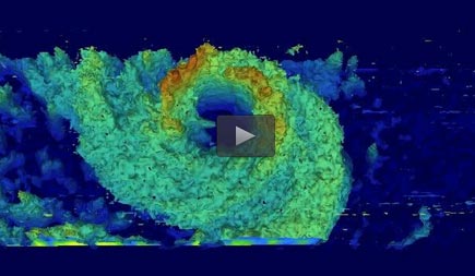
NASA/JAXA's Global Precipitation Measurement (GPM) core observatory satellite passed above Typhoon Nangka on July 15 at 12:21 p.m. EDT and saw the highest thunderstorm tops in the western eye wall were about 12 km (7.4 miles) high. Credit: NASA/JAXA/SSAI, Hal Pierce
NASA/JAXA's Global Precipitation Measurement (GPM) core observatory satellite passed above Typhoon Nangka on July 15, 2015 at 1621 UTC (12:21 p.m. EDT) as the weakening typhoon approached the Japanese island of Shikoku.
GPM's Dual-Frequency Precipitation Radar (DPR) instrument revealed that the highest thunderstorm tops in Nangka's western eye wall were then reaching heights of about 12 km (7.4 miles).
On July 16 at 2:05 UTC (July 15 at 10:05 p.m. EDT) the MODIS instrument aboard NASA's Terra satellite captured a visible image of Typhoon Nangka affecting southeastern Japan.
The MODIS image showed that Nangka maintained its eye and that eye was surrounded by thick, spiraling bands of thunderstorms out to about 150 nautical miles from the center making the storm over 300 nautical miles wide.
By 1500 UTC (11 a.m. EDT), Typhoon Nangka had moved to just 142 nautical miles southeast of Iwakuni, Japan, centered near 32.9 North and 134.4 East. Nangka's maximum sustained winds were down to 65 knots (75 mph/120 kph) making it a minimal category 1 typhoon. Nangka was moving to the north at 10 knots (11.5 mph/18.5 kph).
Nangka is moving north and is approaching a landfall in mainland Japan. The storm is expected to move north over Japan and rapidly weaken as it veers northeast.
Media Contact
All latest news from the category: Earth Sciences
Earth Sciences (also referred to as Geosciences), which deals with basic issues surrounding our planet, plays a vital role in the area of energy and raw materials supply.
Earth Sciences comprises subjects such as geology, geography, geological informatics, paleontology, mineralogy, petrography, crystallography, geophysics, geodesy, glaciology, cartography, photogrammetry, meteorology and seismology, early-warning systems, earthquake research and polar research.


Newest articles

A universal framework for spatial biology
SpatialData is a freely accessible tool to unify and integrate data from different omics technologies accounting for spatial information, which can provide holistic insights into health and disease. Biological processes…

How complex biological processes arise
A $20 million grant from the U.S. National Science Foundation (NSF) will support the establishment and operation of the National Synthesis Center for Emergence in the Molecular and Cellular Sciences (NCEMS) at…

Airborne single-photon lidar system achieves high-resolution 3D imaging
Compact, low-power system opens doors for photon-efficient drone and satellite-based environmental monitoring and mapping. Researchers have developed a compact and lightweight single-photon airborne lidar system that can acquire high-resolution 3D…

