NASA sees Tropical Depression 03W's 'hot tower' on approach to Guam
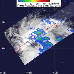
When NASA's TRMM satellite passed over TD03W on May 21, 2012, at 0642 UTC (2:42 a.m. EDT), data revealed a hot tower over 15 kilometers (9.3 miles) high. TRMM also measured rainfall within the tropical depression, and found that isolated areas of heavy rain (falling at a rate of 2 inches/50 mm per hour (appearing in red)) were seen in the western quadrant of the storm. Light to moderate rainfall was falling at a rate between .78 inches and 1.57 inches per hour (20 to 40 mm).<br><br>Credit: NASA/TRMM, Hal Pierce<br>
“Hot Tower” rain clouds within a tropical cyclone indicate that the storm is going to intensify, and that's what NASA's TRMM satellite spotted in newborn Tropical Depression 2E in the eastern Pacific Ocean and now in Tropical Depression 03W (TD03W) in the western North Pacific Ocean.
A “hot tower” as a rain cloud that reaches at least to the top of the troposphere, the lowest layer of the atmosphere. These towers are called “hot” because they rise to such altitude due to the large amount of latent heat. Water vapor releases this latent heat as it condenses into liquid.
When NASA's TRMM satellite passed over TD03W on May 21, 2012 at 0642 UTC (2:42 a.m. EDT), data revealed a hot tower over 15 kilometers (9.3 miles) high. That's an indication that the storm is going to intensify, and that's one factor that forecasters at the Joint Typhoon Warning Center are using in their forecast, which calls for TD03W to become a tropical storm.
TRMM also measured rainfall within the tropical depression, and found that isolated areas of heavy rain (falling at a rate of 2 inches/50 mm per hour) were seen in the western quadrant of the storm. Light-to-moderate rainfall was falling throughout the rest of the storm.
Tropical Depression 03W is close to Guam, just 160 nautical miles south-southeast of Andersen Air Force Base, Guam, near 10.8 North and 145.9 East. It is bringing rain and gusty winds and will continue to do so as it tracks to the west of Guam over the next couple of days and swings to the northeast. Maximum sustained winds are near 25 knots with higher gusts. TD03W is moving to the west, but is expected to turn to the northeast in a couple of days.
Media Contact
More Information:
http://www.nasa.govAll latest news from the category: Earth Sciences
Earth Sciences (also referred to as Geosciences), which deals with basic issues surrounding our planet, plays a vital role in the area of energy and raw materials supply.
Earth Sciences comprises subjects such as geology, geography, geological informatics, paleontology, mineralogy, petrography, crystallography, geophysics, geodesy, glaciology, cartography, photogrammetry, meteorology and seismology, early-warning systems, earthquake research and polar research.


Newest articles

Sea slugs inspire highly stretchable biomedical sensor
USC Viterbi School of Engineering researcher Hangbo Zhao presents findings on highly stretchable and customizable microneedles for application in fields including neuroscience, tissue engineering, and wearable bioelectronics. The revolution in…

Twisting and binding matter waves with photons in a cavity
Precisely measuring the energy states of individual atoms has been a historical challenge for physicists due to atomic recoil. When an atom interacts with a photon, the atom “recoils” in…

Nanotubes, nanoparticles, and antibodies detect tiny amounts of fentanyl
New sensor is six orders of magnitude more sensitive than the next best thing. A research team at Pitt led by Alexander Star, a chemistry professor in the Kenneth P. Dietrich…

