Landsat 5 satellite sees Mississippi River floodwaters lingering
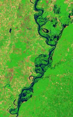
The Landsat 5 satellite Thematic Mapper captured this images on June 11, 2011. In this false-color images, water is navy blue. Depending on land use, land above water is green or burnt orange. The image is rotated, with the left sides facing north. Credit: Credit: NASA Earth Observatory images created by Jesse Allen and Robert Simmon, using Landsat data provided by the United States Geological Survey<br>
On May 19, 2011, the Mississippi River reached a historic crest at Vicksburg. According to the Advanced Hydrological Prediction Service (AHPS) of the U.S. National Weather Service, the river reached 57.10 feet (17.40 meters) that day. By early June, flooding had receded considerably around Vicksburg, but water remained high.
On June 14, the AHPS reported that the Mississippi River reached 44.88 feet (13.68 meters) at Vicksburg. At that point, the river was in minor flood stage, and its level was forecast to continue falling through June 19.
The Landsat series of satellites is used by emergency managers to acquire a range of imagery, from floods to fires. Landsat has recently provided both images of the flooding of the Mississippi River and the fires raging in Arizona.
The Landsat Program is a series of Earth-observing satellite missions jointly managed by NASA and the U.S. Geological Survey. Landsat satellites have been consistently gathering data about our planet since 1972. They continue to improve and expand this unparalleled record of Earth's changing landscapes, for the benefit of all. The next Landsat satellite is scheduled to launch in December 2012.
Media Contact
More Information:
http://www.nasa.govAll latest news from the category: Earth Sciences
Earth Sciences (also referred to as Geosciences), which deals with basic issues surrounding our planet, plays a vital role in the area of energy and raw materials supply.
Earth Sciences comprises subjects such as geology, geography, geological informatics, paleontology, mineralogy, petrography, crystallography, geophysics, geodesy, glaciology, cartography, photogrammetry, meteorology and seismology, early-warning systems, earthquake research and polar research.


Newest articles

A universal framework for spatial biology
SpatialData is a freely accessible tool to unify and integrate data from different omics technologies accounting for spatial information, which can provide holistic insights into health and disease. Biological processes…

How complex biological processes arise
A $20 million grant from the U.S. National Science Foundation (NSF) will support the establishment and operation of the National Synthesis Center for Emergence in the Molecular and Cellular Sciences (NCEMS) at…

Airborne single-photon lidar system achieves high-resolution 3D imaging
Compact, low-power system opens doors for photon-efficient drone and satellite-based environmental monitoring and mapping. Researchers have developed a compact and lightweight single-photon airborne lidar system that can acquire high-resolution 3D…

