NASA Sees Birth of First Southern Indian Ocean Season Tropical Storm
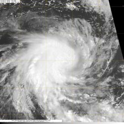
The MODIS instrument on NASA's Aqua satellite captured an image of Tropical Cyclone 01S on Dec. 5 at 08:18 UTC (3:18 a.m. EST) in the Southern Indian Ocean. Strong thunderstorms are visible around the center as they cast shadows on the lower surrounding clouds.<br>Credit: NASA/NRL <br>
Tropical Cyclone 01S (TC01S) formed today December 5, 2011. TC01S has maximum sustained winds near 55 knots (63 mph/102 kmh) and is rapidly consolidating and organizing, so strengthening is forecast. At 0900 UTC (4 a.m. EST) on Dec. 5, TC01S was located about 545 nautical miles west of the Cocos Islands near 12.2 South and 87.0 East. It was moving to the west at 7 knots 8 mph/13 kmh).
The Moderate Resolution Imaging Spectroradiometer (MODIS) instrument on NASA's Aqua satellite captured an image of Tropical Cyclone 01S on Dec. 5 at 08:18 UTC (3:18 a.m. EST) in the Southern Indian Ocean. Strong thunderstorms are visible around the center as they cast shadows on the lower surrounding clouds.
Microwave satellite instruments showed an eye developing in TC01S. There is also tightly curved banding of thunderstorms around the low-level center. T01S has intensified rapidly over the first 12 hours of its existence. The Joint Typhoon Warning Center forecasters expect TC01S to strengthen to hurricane-force over the next two days and track to the southeast, staying at sea.
Text credit: Rob Gutro
NASA's Goddard Space Flight Center, Greenbelt, Md
Media Contact
More Information:
http://www.nasa.govAll latest news from the category: Earth Sciences
Earth Sciences (also referred to as Geosciences), which deals with basic issues surrounding our planet, plays a vital role in the area of energy and raw materials supply.
Earth Sciences comprises subjects such as geology, geography, geological informatics, paleontology, mineralogy, petrography, crystallography, geophysics, geodesy, glaciology, cartography, photogrammetry, meteorology and seismology, early-warning systems, earthquake research and polar research.


Newest articles

A universal framework for spatial biology
SpatialData is a freely accessible tool to unify and integrate data from different omics technologies accounting for spatial information, which can provide holistic insights into health and disease. Biological processes…

How complex biological processes arise
A $20 million grant from the U.S. National Science Foundation (NSF) will support the establishment and operation of the National Synthesis Center for Emergence in the Molecular and Cellular Sciences (NCEMS) at…

Airborne single-photon lidar system achieves high-resolution 3D imaging
Compact, low-power system opens doors for photon-efficient drone and satellite-based environmental monitoring and mapping. Researchers have developed a compact and lightweight single-photon airborne lidar system that can acquire high-resolution 3D…

