NASA satellite shows the Tropical Storm Son-tinh's reach over Philippines
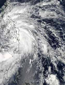
On Oct. 24, 2012 at 0445 UTC (12:45 a.m. EDT) the MODIS instrument captured a visible image of Tropical Storm Son-tinh when its center was moving through the central Philippines.<br><br>Credit: NASA Goddard MODIS Rapid Response Team<br>
On Oct. 24, 2012 at 0445 UTC (12:45 a.m. EDT) the Moderate Resolution Imaging Spectroradiometer (MODIS) instrument that flies aboard NASA's Aqua satellite captured a visible image of Tropical Storm Son-tinh. At the time of the image, Son-tinh's center was moving through the central Philippines, but its cloud cover extended north into Luzon. The image also showed that the strongest thunderstorms were east of the center, and were still over the Philippine Sea.
On Oct. 24 at 1500 UTC (11 a.m. EDT) Tropical Storm Son-tinh had maximum sustained winds near 35 knots (40.2 mph/64.8 kph). It was previously known as the low pressure area called “System 92W.” Son-tinh was centered about 335 miles (385.5 mph/620.4 kph) southeast of Manila, Philippines and raining over much of the country. Son-tinh's center was near 10.7 North latitude and 125.2 East longitude and moving to the northwest at 17 knots (19.5 mph/31.4 kph).
The warnings continue in the Philippines as Son-tinh tracks west and toward the South China Sea. Public storm warning signal #1 was in effect on Oct. 24 (Eastern Daylight Time) for the for the Visayas province of Northern Samar, Antique, Iloilo, Southern Negros, Southern Cebu and Bohol; also for the Mindanao provinces of Surigao del Norte and Siargao Island. Public storm warning signal #1 was also in effect for the Luzon provinces of Camarines Sur, Albay, Sorsogon, Burias Island, Southern Quezon, Marinduque, Oriental and Occidental Mindoro, Calamian Group of Islands, Batangas, Lubang Island and Cuyo Island.
In addition, Public storm warning signal #2 was in effect for the Visayas provinces of Eastern and Western Samar; Leyte, Southern Leyte, Biliran Island, Camotes Island, Capiz, Aklan, Boracay Island, Northern Cebu, Bantayan Island and Northern Negros; and the Mindanao province of Dinagat Island. Public storm warning #2 was also in effect for the Luzon provinces of Masbate and Romblon.
The Joint Typhoon Warning Center expects Son-tinh to move northwest across the Philippine islands into the South China Sea and make a landfall on the Vietnamese coastline.
Media Contact
More Information:
http://www.nasa.govAll latest news from the category: Earth Sciences
Earth Sciences (also referred to as Geosciences), which deals with basic issues surrounding our planet, plays a vital role in the area of energy and raw materials supply.
Earth Sciences comprises subjects such as geology, geography, geological informatics, paleontology, mineralogy, petrography, crystallography, geophysics, geodesy, glaciology, cartography, photogrammetry, meteorology and seismology, early-warning systems, earthquake research and polar research.


Newest articles

A universal framework for spatial biology
SpatialData is a freely accessible tool to unify and integrate data from different omics technologies accounting for spatial information, which can provide holistic insights into health and disease. Biological processes…

How complex biological processes arise
A $20 million grant from the U.S. National Science Foundation (NSF) will support the establishment and operation of the National Synthesis Center for Emergence in the Molecular and Cellular Sciences (NCEMS) at…

Airborne single-photon lidar system achieves high-resolution 3D imaging
Compact, low-power system opens doors for photon-efficient drone and satellite-based environmental monitoring and mapping. Researchers have developed a compact and lightweight single-photon airborne lidar system that can acquire high-resolution 3D…

