NASA satellite sees Tropical Storm Mangkhut making Vietnam landfall
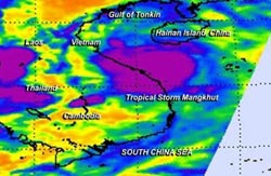
This Aug. 6 infrared image from AIRS on NASA's Aqua satellite showed that cloud top temperatures in Mangkhut are as cold as 210 kelvin/-81F/-63Ct (purple) indicating powerful storms.<br><br>Credit: NASA/JPL<br>
On Aug. 6 at 20:55 UTC (4:55 p.m. EDT) NASA's Aqua satellite flew over Mangkhut as it tracked west-northwest through the Gulf of Tonkin on its way to a landfall. Aqua's Atmospheric Infrared Sounder or AIRS instrument captured infrared data that showed that cloud top temperatures of some thunderstorms around Mangkhut's center were as cold as 210 kelvin/-81F/-63C indicating powerful storms with the potential for heavy rainfall.
The AIRS data also measures temperatures over land, and in the same image where it captured Tropical Storm Mangkhut, the data showed some of the surface temperatures in eastern central China appeared warmer than 300 kelvin/80F/26.8C at 1841 UTC on Aug. 6 or 2:41 a.m. China local time. Those are warm overnight temperatures!
Early on Aug. 7, the Joint Typhoon Warning Center noted that “Animated infrared satellite imagery shows the deep convective bands associated with the system have collapsed as they began to interact with the topography of Vietnam.” A Tropical Storm Warning remains in effect for Aug. 7, according to the Vietnam National Centre for Hydro-Meteorological Forecasting.
At 1500 UTC (11 a.m. EDT) on Aug. 7, Mangkhut's center was very close to landfall. Maximum sustained winds were near 35 knots, making it a minimal tropical storm. Mangkhut was about 92 nautical miles/106 miles/170 km south of Hanoi, Vietnam, near 19.8 north latitude and 105.8 east longitude. It was moving to the west-northwest at 13 knots/15 mph/24 kph.
After Mangkhut makes landfall about 65 miles south of Hanoi, the storm is expected to dissipate within 24 hours.
Media Contact
More Information:
http://www.nasa.govAll latest news from the category: Earth Sciences
Earth Sciences (also referred to as Geosciences), which deals with basic issues surrounding our planet, plays a vital role in the area of energy and raw materials supply.
Earth Sciences comprises subjects such as geology, geography, geological informatics, paleontology, mineralogy, petrography, crystallography, geophysics, geodesy, glaciology, cartography, photogrammetry, meteorology and seismology, early-warning systems, earthquake research and polar research.


Newest articles

High-energy-density aqueous battery based on halogen multi-electron transfer
Traditional non-aqueous lithium-ion batteries have a high energy density, but their safety is compromised due to the flammable organic electrolytes they utilize. Aqueous batteries use water as the solvent for…

First-ever combined heart pump and pig kidney transplant
…gives new hope to patient with terminal illness. Surgeons at NYU Langone Health performed the first-ever combined mechanical heart pump and gene-edited pig kidney transplant surgery in a 54-year-old woman…

Biophysics: Testing how well biomarkers work
LMU researchers have developed a method to determine how reliably target proteins can be labeled using super-resolution fluorescence microscopy. Modern microscopy techniques make it possible to examine the inner workings…

