NASA's Terra satellite sees Tropical Cyclone Glenda stretching out
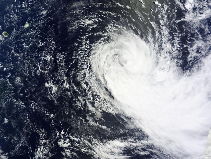
NASA's Terra satellite captured a visible image of Glenda on Feb. 27 that revealed the bulk of storm's clouds pushed southeast of the center. Credit: NASA Goddard MODIS Rapid Response Team
When Terra passed over the Southern Indian Ocean on Feb. 27, the Moderate Resolution Imaging Spectroradiometer (MODIS) instrument captured a visible image of the storm.
In the image, the bulk of clouds associated with the storm appeared to be pushed southeast of the center and away from the islands of Mauritius and La Reunion.
The Joint Typhoon Warning Center (JTWC) noted today, Feb. 27, “animated multispectral satellite imagery shows the system has begun to show signs of elongation as the main convective bands are displaced eastward of a partially-exposed low-level circulation center.”
At 0900 UTC (4 a.m. EST), Glenda's maximum sustained winds had dropped to near 45 knots (51.7 mph/83.3 kph). Glenda was centered near 22.4 south latitude and 67.2 east longitude, about 573 nautical miles (659.4 miles/1,061 km) east-southeast of Port Louis, Mauritius. Glenda was moving to the south at 7 knots (8 mph/12.9 kph).
JTWC reported in their upper-level atmosphere analysis that Glenda is located in a “marginal environment with moderate vertical wind shear offset by excellent poleward outflow.”
By Saturday, Feb. 28, Glenda is expected to transition to an extra-tropical storm and become a cold-core system.
Media Contact
All latest news from the category: Earth Sciences
Earth Sciences (also referred to as Geosciences), which deals with basic issues surrounding our planet, plays a vital role in the area of energy and raw materials supply.
Earth Sciences comprises subjects such as geology, geography, geological informatics, paleontology, mineralogy, petrography, crystallography, geophysics, geodesy, glaciology, cartography, photogrammetry, meteorology and seismology, early-warning systems, earthquake research and polar research.


Newest articles

A universal framework for spatial biology
SpatialData is a freely accessible tool to unify and integrate data from different omics technologies accounting for spatial information, which can provide holistic insights into health and disease. Biological processes…

How complex biological processes arise
A $20 million grant from the U.S. National Science Foundation (NSF) will support the establishment and operation of the National Synthesis Center for Emergence in the Molecular and Cellular Sciences (NCEMS) at…

Airborne single-photon lidar system achieves high-resolution 3D imaging
Compact, low-power system opens doors for photon-efficient drone and satellite-based environmental monitoring and mapping. Researchers have developed a compact and lightweight single-photon airborne lidar system that can acquire high-resolution 3D…

