NASA's TRMM satellite sees birth of Arabian Sea cyclone
TRMM passed above the first tropical cyclone of 2012 as it was forming in the Arabian Sea on October 2012 at 11:13 a.m. EDT. TRMM saw that rain at the surface was falling at a rate of up to 41 mm/hour (~1.6 inches) and thunderstorms within were reaching heights of over 16 km (~9.9 miles).<br><br>Credit: SSAI/NASA, Hal Pierce<br>
Since it was launched in 1997 the Tropical Rainfall Measuring Mission (TRMM) satellite has been useful for monitoring tropical cyclones in the tropics. TRMM passed above the first tropical cyclone of 2012 (TC01A) as it was forming in the Arabian Sea on October 2012 at 1513 UTC (11:13 a.m. EDT). Rainfall from TRMM's Microwave Imager (TMI) and Precipitation Radar (PR) were overlaid on an enhanced infrared image from TRMM's Visible and InfraRed Scanner (VIRS) to provide a complete picture of rainfall rates occurring within the storm.
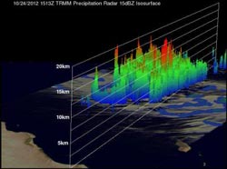
TRMM PR and TMI data showed that rain at the surface was falling at a rate of up to 41 mm/hour (~1.6 inches) in the forming tropical cyclone. Bands of thunderstorms were also wrapping tightly into a well-defined low level center of circulation. TRMM PR data also was also used to create a 3-D image that showed the vertical structure of convective storms in the area. The view showed some towering convective storms were reaching heights of over 16 km (~9.9 miles).
Another satellite passed over TC01A and captured infrared data on the storm, revealing temperature of cloud tops. The colder the cloud top, the higher the thunderstorm is in the atmosphere, and the more powerful the storm. The Atmospheric Infrared Sounder (AIRS) instrument aboard NASA's Aqua satellite captured infrared imagery of Tropical Storm 01A on Oct. 24 at 5:35 a.m. EDT (0935 UTC) that showed the strongest thunderstorms surrounded the center of circulation. Those thunderstorms were reaching high into the troposphere where cloud top temperatures are as cold as -63 Fahrenheit (-52 Celsius).
On Oct. 24 at 1500 UTC (11 a.m. EDT), TC01A had maximum sustained winds near 35 knots (~40 mph). It was located about 300 nautical miles east-southeast of Cape Guardafui, Somalia, near 10.4 North latitude and 55.7 East longitude. TC01A was moving to the west at 16 knots and is expected to move to the west-southwest over the next couple of days before making landfall south of Cape Guardafui, Somalia. Cape Guardafui is located in the northeastern Bari province and forms the geographical point of the Horn of Africa.
Tropical cyclone 01A is predicted by the U.S. Navy Joint Typhoon Warning Center (JTWC) to hit northeastern Somalia on October 25, 2012 with wind speeds of about 35 knots (~40 mph).
Media Contact
More Information:
http://www.nasa.govAll latest news from the category: Earth Sciences
Earth Sciences (also referred to as Geosciences), which deals with basic issues surrounding our planet, plays a vital role in the area of energy and raw materials supply.
Earth Sciences comprises subjects such as geology, geography, geological informatics, paleontology, mineralogy, petrography, crystallography, geophysics, geodesy, glaciology, cartography, photogrammetry, meteorology and seismology, early-warning systems, earthquake research and polar research.


Newest articles

A universal framework for spatial biology
SpatialData is a freely accessible tool to unify and integrate data from different omics technologies accounting for spatial information, which can provide holistic insights into health and disease. Biological processes…

How complex biological processes arise
A $20 million grant from the U.S. National Science Foundation (NSF) will support the establishment and operation of the National Synthesis Center for Emergence in the Molecular and Cellular Sciences (NCEMS) at…

Airborne single-photon lidar system achieves high-resolution 3D imaging
Compact, low-power system opens doors for photon-efficient drone and satellite-based environmental monitoring and mapping. Researchers have developed a compact and lightweight single-photon airborne lidar system that can acquire high-resolution 3D…

