NASA sees Tropical Cyclone Adjali develop a tail
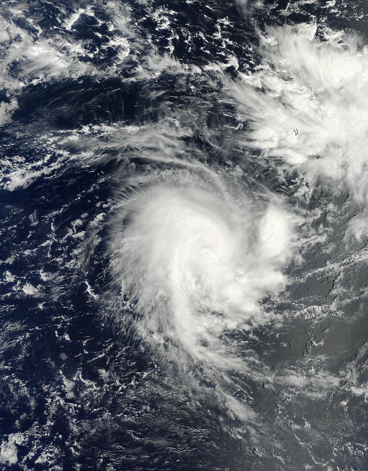
This visible image of Tropical Storm Adjali was taken on Nov. 18 at 05:35 UTC from the MODIS instrument aboard NASA's Terra satellite. Credit: NRL/NOAA/NASA
The Moderate Resolution Imaging Spectroradiometer, or MODIS instrument that flies aboard NASA's Terra satellite took a visible picture of Tropical Storm Adjali on Nov. 18 at 05:35 UTC (12:35 a.m. EST).
The MODIS image showed a concentration of strong storms around the center of Adjali's circulation and a band of thunderstorms extending south of the center, resembling a “tail.”
On Nov. 18, the Joint Typhoon Warning Center (JTWC) noted that bands of thunderstorms spiraling into the low-level center appeared to be weakening on microwave satellite imagery.
By 0900 UTC (4 a.m. EDT), Adjali's maximum sustained winds were near 60 knots (69/0 mph/111 kph). It was centered near 11.2 south latitude and 70.0 east longitude, about 279 nautical miles (321.1 miles/516.7 km) southwest of Diego Garcia.
Diego Garcia is an island in the central Indian Ocean, and is part of the British Indian Ocean Territory.
Adjali had changed directions since Nov. 17 and was now moving to the southwest at 9 knots (10.3 mph/16.6 kph). Forecasters at JTWC now expect the storm to maintain intensity or slightly weaken over the next day.
After that time, JTWC forecasters expect Adjali to weaken to a depression as it moves through cooler waters.
Media Contact
More Information:
http://www.nasa.govAll latest news from the category: Earth Sciences
Earth Sciences (also referred to as Geosciences), which deals with basic issues surrounding our planet, plays a vital role in the area of energy and raw materials supply.
Earth Sciences comprises subjects such as geology, geography, geological informatics, paleontology, mineralogy, petrography, crystallography, geophysics, geodesy, glaciology, cartography, photogrammetry, meteorology and seismology, early-warning systems, earthquake research and polar research.


Newest articles

A universal framework for spatial biology
SpatialData is a freely accessible tool to unify and integrate data from different omics technologies accounting for spatial information, which can provide holistic insights into health and disease. Biological processes…

How complex biological processes arise
A $20 million grant from the U.S. National Science Foundation (NSF) will support the establishment and operation of the National Synthesis Center for Emergence in the Molecular and Cellular Sciences (NCEMS) at…

Airborne single-photon lidar system achieves high-resolution 3D imaging
Compact, low-power system opens doors for photon-efficient drone and satellite-based environmental monitoring and mapping. Researchers have developed a compact and lightweight single-photon airborne lidar system that can acquire high-resolution 3D…

