NASA Sees a Weaker Tropical Storm Julio Far North of Hawaii
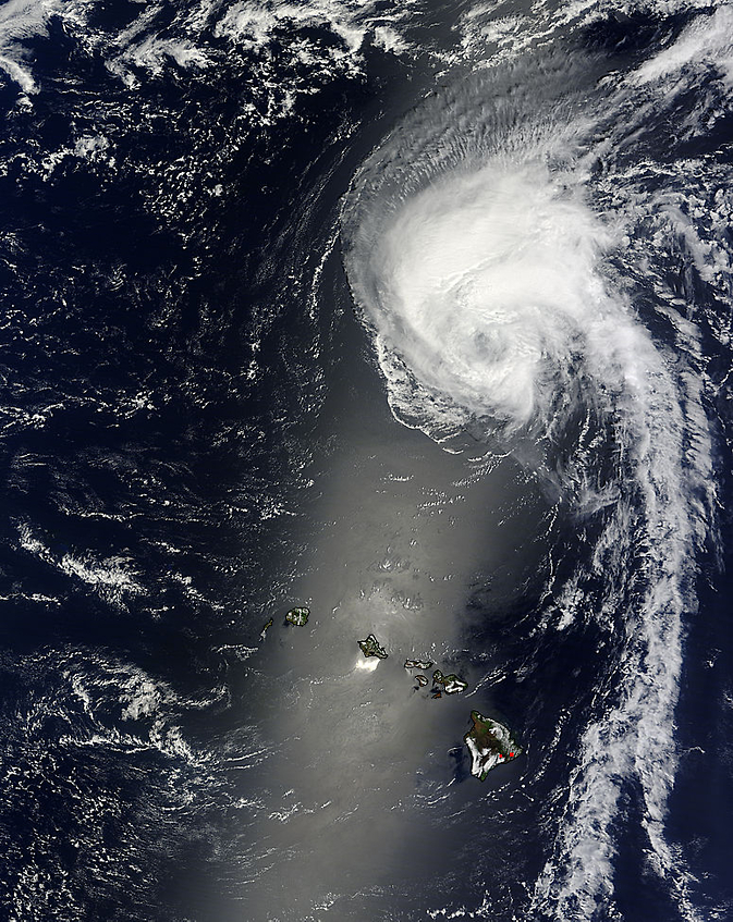
NASA's Terra satellite captured this visible image of Tropical Storm Julio far north of Hawaii on August 11 at 21:25 UTC. Image Credit: NASA Goddard MODIS Rapid Response Team
NASA's Terra satellite passed over Julio and saw that the bulk of the clouds and precipitation were being pushed to the34 north of the center as the storm tracked far north of the Hawaiian Islands.
NASA's Terra satellite passed over Julio on August 11 at 21:25 UTC (5:25 p.m. EDT) and the Moderate Resolution Imaging Spectroradiometer or MODIS instrument aboard took a visible picture of the storm.
The MODIS image revealed a circular center, but most of the clouds and showers associated with the storm were pushed north of the center. Drier air, located over the southern quadrant of the storm is sapping the development of thunderstorms.
Julio tracked far enough away from the Hawaiian Islands so that no watches or warnings were generated for the storm.
At 5 a.m. HST local time (1500 UTC/11 a.m. EDT) on August 12, the center of Tropical Storm Julio was located near latitude 28.6 north, longitude 157.1 west, about 505 miles (815 km) north of Honolulu Hawaii.
Julio was moving toward the northwest near 6 mph (9 kph) and NOAA's Central Pacific Hurricane Center (CPHC) expects that motion to continue over the next day before the storm gradually turns north.
Maximum sustained winds were near 65 mph (100 kph) and a slow weakening is forecast over the next two days.
The CPHC expects that cooler waters and increasing wind shear will weaken Julio into a depression by August 14.
Text credit: Rob Gutro
NASA's Goddard Space Flight Center
Media Contact
All latest news from the category: Earth Sciences
Earth Sciences (also referred to as Geosciences), which deals with basic issues surrounding our planet, plays a vital role in the area of energy and raw materials supply.
Earth Sciences comprises subjects such as geology, geography, geological informatics, paleontology, mineralogy, petrography, crystallography, geophysics, geodesy, glaciology, cartography, photogrammetry, meteorology and seismology, early-warning systems, earthquake research and polar research.


Newest articles

Recovering phosphorus from sewage sludge ash
Chemical and heat treatment of sewage sludge can recover phosphorus in a process that could help address the problem of diminishing supplies of phosphorus ores. Valuable supplies of phosphorus could…

Efficient, sustainable and cost-effective hybrid energy storage system for modern power grids
EU project HyFlow: Over three years of research, the consortium of the EU project HyFlow has successfully developed a highly efficient, sustainable, and cost-effective hybrid energy storage system (HESS) that…

After 25 years, researchers uncover genetic cause of rare neurological disease
Some families call it a trial of faith. Others just call it a curse. The progressive neurological disease known as spinocerebellar ataxia 4 (SCA4) is a rare condition, but its…

