NASA looks at rare Arabian Sea tropical cyclone in 3-D
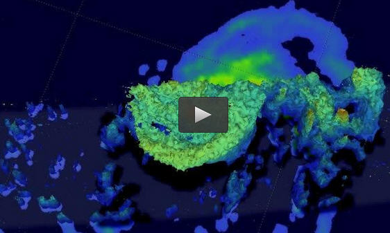
This GPM core satellite 3-D view of tropical cyclone Ashobaa revealed the storm had very powerful thunderstorms near the center of the newly formed storm reaching heights above 17 km (10.5 miles). Courtesy of SSAI/NASA/JAXA, Hal Pierce
The GPM core observatory satellite flew over Ashobaa on the morning of June 8 at 0811 UTC (4:11 a.m. EDT). Tropical cyclone Ashobaa had sustained wind speeds of about 40 knots (46 mph) when the satellite passed overhead.
On June 9 at 0900 UTC (5 a.m. EDT), tropical cyclone Ashobaa had maximum sustained winds near 50 knots (57.5 mph/92.6 kph). Ashobaa was centered near 20.7 north latitude and 64.1 east longitude, about 290 nautical miles (333.7 miles/ 537.1 km) south-southwest of Karachi, Pakistan. Ashobaa is moving west-northwest at 8 knots (9.2 mph/14.8 kph).
Satellite data on June 9 showed that the storm is tightly wrapped, although elongated as clouds and showers are being pushed to the west because of persistent moderate easterly wind shear.
The Joint Typhoon Warning Center (JTWC) predicts that tropical cyclone Ashobaa will become more powerful and have winds of 65 knots (about 75 mph) by June 10 as it moves through warm sea surface temperatures. Ashobaa is then predicted to weaken as dry stable air is expected to affect the system. It is forecast to turn west where it expected to make landfall on June 12 near Ras al Hadd, a village in the Ash Sharqiyah district in Oman.
As Ashobaa continues curving to the west in the Arabian Sea, it is generating rough surf along the coasts of Oman, southeastern Iran and Pakistan.
GPM's Microwave Imager (GMI) and Dual-Frequency Precipitation Radar (DPR) instruments measured rain falling at a rate of over 60 mm (2.3 inches) per hour in strong thunderstorms southwest of the storm's center of circulation.
###
At NASA's Goddard Space Flight Center in Greenbelt, Md., a 3-D view was constructed using data from DPR Ku band radar data. The 3-D view of GPM revealed Ashobaa had very powerful thunderstorms near the center of the newly formed storm reaching heights above 17 km (10.5 miles). These tall thunderstorms near the center of a tropical cyclone can be as sign that intensification will occur in the future.
Media Contact
All latest news from the category: Earth Sciences
Earth Sciences (also referred to as Geosciences), which deals with basic issues surrounding our planet, plays a vital role in the area of energy and raw materials supply.
Earth Sciences comprises subjects such as geology, geography, geological informatics, paleontology, mineralogy, petrography, crystallography, geophysics, geodesy, glaciology, cartography, photogrammetry, meteorology and seismology, early-warning systems, earthquake research and polar research.


Newest articles

Trotting robots reveal emergence of animal gait transitions
A four-legged robot trained with machine learning by EPFL researchers has learned to avoid falls by spontaneously switching between walking, trotting, and pronking – a milestone for roboticists as well…

Innovation promises to prevent power pole-top fires
Engineers in Australia have found a new way to make power-pole insulators resistant to fire and electrical sparking, promising to prevent dangerous pole-top fires and reduce blackouts. Pole-top fires pose…

Possible alternative to antibiotics produced by bacteria
Antibacterial substance from staphylococci discovered with new mechanism of action against natural competitors. Many bacteria produce substances to gain an advantage over competitors in their highly competitive natural environment. Researchers…

