USGS releases first-ever comprehensive geologic map of the moon
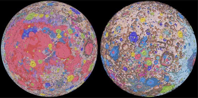
New Unified Geologic Map of the Moon with shaded topography from the Lunar Orbiter Laser Altimeter (LOLA). This geologic map is a synthesis of six Apollo-era regional geologic maps, updated based on data from recent satellite missions. It will serve as a reference for lunar science and future human missions to the Moon. Credit: NASA/GSFC/USGS
For the first time, the entire lunar surface has been completely mapped and uniformly classified by scientists from the USGS, in collaboration with NASA and the Lunar Planetary Institute.
The lunar map, called the “Unified Geologic Map of the Moon,” will serve as the definitive blueprint of the moon's surface geology for future human missions and will be invaluable for the international scientific community, educators and the public-at-large. The digital map is available online now and shows the moon's geology in incredible detail (1:5,000,000 scale).
“People have always been fascinated by the moon and when we might return,” said current USGS Director and former NASA astronaut Jim Reilly. “So, it's wonderful to see USGS create a resource that can help NASA with their planning for future missions.”
To create the new digital map, scientists used information from six Apollo-era regional maps along with updated information from recent satellite missions to the moon. The existing historical maps were redrawn to align them with the modern data sets, thus preserving previous observations and interpretations.
Along with merging new and old data, USGS researchers also developed a unified description of the stratigraphy, or rock layers, of the moon. This resolved issues from previous maps where rock names, descriptions and ages were sometimes inconsistent.
“This map is a culmination of a decades-long project,” said Corey Fortezzo, USGS geologist and lead author. “It provides vital information for new scientific studies by connecting the exploration of specific sites on the moon with the rest of the lunar surface.”
Elevation data for the moon's equatorial region came from stereo observations collected by the Terrain Camera on the recent SELENE (Selenological and Engineering Explorer) mission led by JAXA, the Japan Aerospace Exploration Agency. Topography for the north and south poles was supplemented with NASA's Lunar Orbiter Laser Altimeter data.
###
For more details about the map, read the abstract or download it directly at the Unified Geologic Map of the Moon website.
USGS provides science for a changing world. For more information, visit http://www.
Media Contact
All latest news from the category: Physics and Astronomy
This area deals with the fundamental laws and building blocks of nature and how they interact, the properties and the behavior of matter, and research into space and time and their structures.
innovations-report provides in-depth reports and articles on subjects such as astrophysics, laser technologies, nuclear, quantum, particle and solid-state physics, nanotechnologies, planetary research and findings (Mars, Venus) and developments related to the Hubble Telescope.


Newest articles

A universal framework for spatial biology
SpatialData is a freely accessible tool to unify and integrate data from different omics technologies accounting for spatial information, which can provide holistic insights into health and disease. Biological processes…

How complex biological processes arise
A $20 million grant from the U.S. National Science Foundation (NSF) will support the establishment and operation of the National Synthesis Center for Emergence in the Molecular and Cellular Sciences (NCEMS) at…

Airborne single-photon lidar system achieves high-resolution 3D imaging
Compact, low-power system opens doors for photon-efficient drone and satellite-based environmental monitoring and mapping. Researchers have developed a compact and lightweight single-photon airborne lidar system that can acquire high-resolution 3D…

