Wilfire smoke over Alaska
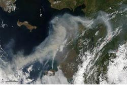
On June 19, 2013, the Moderate Resolution Imaging Spectroradiometer on NASA's Aqua satellite captured this image of smoke from wildfires burning in western Alaska. The smoke was moving west over Norton Sound. (The center of the image is roughly 163° West and 62° North.) Red outlines indicate hot spots where MODIS detected unusually warm surface temperatures associated with fire.<br><br>Credit: NASA image by Jeff Schmaltz, LANCE/EOSDIS Rapid Response. Caption by Adam Voiland.<br>
The smoke was moving west over Norton Sound. (The center of the image is roughly 163° West and 62° North.)
Red outlines indicate hot spots where MODIS detected unusually warm surface temperatures associated with fire.
According to an advisory released by the Alaska Interagency Coordination Center, record heat and dry fuels have produced record-setting fire potential across boreal spruce forests and tundra landscapes.
The heat wave is the product of an intense ridge of high pressure over the state.
Media Contact
More Information:
http://www.nasa.govAll latest news from the category: Earth Sciences
Earth Sciences (also referred to as Geosciences), which deals with basic issues surrounding our planet, plays a vital role in the area of energy and raw materials supply.
Earth Sciences comprises subjects such as geology, geography, geological informatics, paleontology, mineralogy, petrography, crystallography, geophysics, geodesy, glaciology, cartography, photogrammetry, meteorology and seismology, early-warning systems, earthquake research and polar research.


Newest articles

A universal framework for spatial biology
SpatialData is a freely accessible tool to unify and integrate data from different omics technologies accounting for spatial information, which can provide holistic insights into health and disease. Biological processes…

How complex biological processes arise
A $20 million grant from the U.S. National Science Foundation (NSF) will support the establishment and operation of the National Synthesis Center for Emergence in the Molecular and Cellular Sciences (NCEMS) at…

Airborne single-photon lidar system achieves high-resolution 3D imaging
Compact, low-power system opens doors for photon-efficient drone and satellite-based environmental monitoring and mapping. Researchers have developed a compact and lightweight single-photon airborne lidar system that can acquire high-resolution 3D…

