Tropical Depression 8E Forms On Mexican Coastline, Watches Up
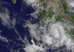
This GOES-11 image from Aug. 31 at 12:15 p.m. EDT, shows Tropical Depression 8E as a rounded swirl of clouds hugging Mexico's southwestern coastline. Credit: NASA/NOAA GOES Project <br>
Forecasters noticed the depression develop more rounded characteristics on imagery from NOAA's GOES-11 satellite today. The image was created by the NASA GOES Project at NASA's Goddard Space Flight Center, Greenbelt, Md.
On Aug. 30, NASA's Tropical Rainfall Measuring Mission (TRMM) satellite noticed some isolated areas of heavy rainfall within the low pressure area before it organized. Some areas had rainfall rates of 2 inches (50 mm) per hour.
Today, August 31 at 11 a.m. EDT, Tropical Depression 8E had maximum sustained winds near 35 mph. It was located just 75 miles (120 km) west-northwest of Zihuatanejo, Mexico, near 18.0 North and 102.7 West. It was moving northwest near 7 mph (11 kmh) and is expected to crawl in that direction over the next couple of days, making rainfall a problem for coastal areas.
Tropical Depression 8E is forecast to hug the western Mexico coastline over the next couple of days, and not strengthen because of its proximity to land. It will, however bring heavy rainfall to coastal sections of the Mexican states of Guerrero, Michoacan and Colima. The National Hurricane Center expects 4 to 6 inches with isolated maximum amounts of 12 inches.
The depression is expected to be short-lived because of its interaction with land, and the National Hurricane Center forecasts it to become a remnant low by late Thursday.
Text credit: Rob Gutro, NASA's Goddard Space Flight Center, Greenbelt, Md.
Media Contact
All latest news from the category: Earth Sciences
Earth Sciences (also referred to as Geosciences), which deals with basic issues surrounding our planet, plays a vital role in the area of energy and raw materials supply.
Earth Sciences comprises subjects such as geology, geography, geological informatics, paleontology, mineralogy, petrography, crystallography, geophysics, geodesy, glaciology, cartography, photogrammetry, meteorology and seismology, early-warning systems, earthquake research and polar research.


Newest articles

A universal framework for spatial biology
SpatialData is a freely accessible tool to unify and integrate data from different omics technologies accounting for spatial information, which can provide holistic insights into health and disease. Biological processes…

How complex biological processes arise
A $20 million grant from the U.S. National Science Foundation (NSF) will support the establishment and operation of the National Synthesis Center for Emergence in the Molecular and Cellular Sciences (NCEMS) at…

Airborne single-photon lidar system achieves high-resolution 3D imaging
Compact, low-power system opens doors for photon-efficient drone and satellite-based environmental monitoring and mapping. Researchers have developed a compact and lightweight single-photon airborne lidar system that can acquire high-resolution 3D…

