Stretched-out low soaking the Caribbean in GOES-13 satellite imagery
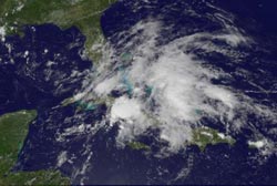
This visible image from the GOES-13 satellite taken at 1740 UTC (1:40 p.m. EDT) shows the large, elongated area of low pressure over eastern Cuba, Jamaica and Hispaniola. Credit: NASA/NOAA GOES Project, Dennis Chesters<br>
The Geostationary Operational Environmental Satellite called GOES-13 captured an image of this low on June 9 at 1740 UTC (1:40 p.m. EDT) System 94L, and the cloud cover appears centered over eastern Cuba and Jamaica while the outer portion of the low stretches over Hispaniola, Puerto Rico and now south Florida. The elongated low has a minimum central pressure of 1001 millibars and is centered near 20 North and 83 West.
During the afternoon of June 9, Flash Flood warnings were in effect in Puerto Rico for the municipalities of Guaynabo, Carolina and San Juan until 4 p.m. AST. According to the National Weather Service website, “at 1:54 p.m. AST National Weather Service doppler radar indicated that heavy rain continues over the warned area and the Piedras River has overflowed its banks and will flood a number of streets.” An Urban and Small Stream Flood Advisory is also in effect for many municipalities.
The forecast calls for showers and thunderstorms across western and northwestern Puerto Rico over the next few days. These showers will bring heavy rainfall and local flooding is possible. In addition to Puerto Rico, the rainfall is also now affecting the U.S/U.K. Virgin Islands and Leeward Islands north of 16 North and east of 67 West.
The GOES series of satellites are operated by NOAA, and the NASA GOES Project at NASA's Goddard Space Flight Center in Greenbelt, Md. created the image of today's low pressure area. The NASA GOES Project also creates animations of GOES satellite imagery and that can be found at: http://goes.gsfc.nasa.gov/.
System 94L continues to produce disorganized showers and thunderstorms that are bringing heavy rainfall to Haiti, the Dominican Republic, Jamaica and Cuba. The low is expected to slowly move northeast.
Media Contact
More Information:
http://www.nasa.govAll latest news from the category: Earth Sciences
Earth Sciences (also referred to as Geosciences), which deals with basic issues surrounding our planet, plays a vital role in the area of energy and raw materials supply.
Earth Sciences comprises subjects such as geology, geography, geological informatics, paleontology, mineralogy, petrography, crystallography, geophysics, geodesy, glaciology, cartography, photogrammetry, meteorology and seismology, early-warning systems, earthquake research and polar research.


Newest articles

High-energy-density aqueous battery based on halogen multi-electron transfer
Traditional non-aqueous lithium-ion batteries have a high energy density, but their safety is compromised due to the flammable organic electrolytes they utilize. Aqueous batteries use water as the solvent for…

First-ever combined heart pump and pig kidney transplant
…gives new hope to patient with terminal illness. Surgeons at NYU Langone Health performed the first-ever combined mechanical heart pump and gene-edited pig kidney transplant surgery in a 54-year-old woman…

Biophysics: Testing how well biomarkers work
LMU researchers have developed a method to determine how reliably target proteins can be labeled using super-resolution fluorescence microscopy. Modern microscopy techniques make it possible to examine the inner workings…

