NASA takes Tropical Cyclone Nanuak's temperature
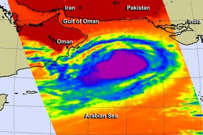
This infrared AIRS instrument image from June 12 at 5:11 a.m. EDT shows powerful thunderstorms around Nanauk's center (purple) and a band of thunderstorms that almost completely circling the storm with the exception of the southwestern quadrant. Credit: NASA JPL, Ed Olsen
In terms of infrared data viewing tropical cyclones, those with the coldest cloud top temperatures indicate that a storm is the most healthy, most robust and powerful. That's because thunderstorms that have strong uplift are pushed to the top of the troposphere where temperatures are bitter cold.
Infrared data, such as that collected from the Atmospheric Infrared Sounder (AIRS) instrument that flies aboard NASA's Aqua satellite can tell those temperatures.
If AIRS data shows that cloud top temperatures are near or colder than -63 Fahrenheit (-53 Celsius), that indicates strong thunderstorms high up in the troposphere. According to research with AIRS data, thunderstorms with cloud top temperatures that high are likely to generate heavy rainfall.
So, when Aqua flew over Tropical Cyclone Nanauk on June 12 at 9:11 UTC (5:11 a.m. EDT) temperatures of the many thunderstorms that circled the center of Nanauk were that cold or colder.
The AIRS image also showed a band of thunderstorms that almost completely circled the storm, with the exception of the southwestern quadrant. Nanauk also seemed to fill up the northern part of the Arabian Sea.
On June 12 at 1500 UTC (11 a.m. EDT), Tropical Cyclone Nanauk was located approximately 425 nautical miles (489 miles/787 km) southeast of Muscat, Oman, near 18.3 north latitude and 63.4 east longitude. Nanauk was moving to the west at 10 knots (11.5 mph/18.5 kph). Maximum sustained winds remained near 55 knots (63.2 mph/102 kph).
Nanauk faces several challenges over the next couple of days, according to the Joint Typhoon Warning Center. Three factors will weaken the system quickly: increasing vertical wind shear, dry air moving into the tropical cyclone and cooler sea surface temperatures.
Nanauk is forecast to continue tracking west-northwestward over the next day or two before succumbing to a more hostile environment.
Media Contact
All latest news from the category: Earth Sciences
Earth Sciences (also referred to as Geosciences), which deals with basic issues surrounding our planet, plays a vital role in the area of energy and raw materials supply.
Earth Sciences comprises subjects such as geology, geography, geological informatics, paleontology, mineralogy, petrography, crystallography, geophysics, geodesy, glaciology, cartography, photogrammetry, meteorology and seismology, early-warning systems, earthquake research and polar research.


Newest articles

A universal framework for spatial biology
SpatialData is a freely accessible tool to unify and integrate data from different omics technologies accounting for spatial information, which can provide holistic insights into health and disease. Biological processes…

How complex biological processes arise
A $20 million grant from the U.S. National Science Foundation (NSF) will support the establishment and operation of the National Synthesis Center for Emergence in the Molecular and Cellular Sciences (NCEMS) at…

Airborne single-photon lidar system achieves high-resolution 3D imaging
Compact, low-power system opens doors for photon-efficient drone and satellite-based environmental monitoring and mapping. Researchers have developed a compact and lightweight single-photon airborne lidar system that can acquire high-resolution 3D…

