NASA sees Tropical Storm Songda singing of rain and gusty winds for the Philippines
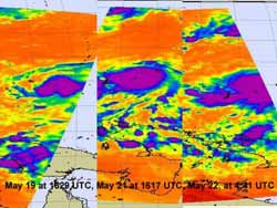
This series of three infrared images shows the strengthening of Tropical Storm Songda over the period of May 19-22, 2011. Notice that the area with strongest convection (purple) has expanded over that time. That area has the coldest, highest thunderstorm cloud tops near -63 F/-52C, and heaviest rainfall. Over those four days, Songda took on a more rounded shape. Credit: NASA/JPL, Ed Olsen<br>
In a series of three infrared images from the period of May 19-22, 2011, NASA's Atmospheric Infrared Sounder (AIRS) instrument revealed the strengthening of Tropical Storm Songda. The area with strongest convection has expanded and organized over that time. That area of strongest convection has the coldest, highest thunderstorm cloud tops near -63 F/-52C, and heaviest rainfall.
The time series of imagery over those four days also shows that Songda took on a more rounded shape as it continued to strengthen from a tropical depression to a tropical storm. Today, May 23, satellite imagery shows a strong band of deep convection is persisting along the southern edge of Songda.
On May 21, Tropical Storm 04W still had maximum sustained winds near 40 mph (35 knots/64 kmh). On Sunday, May 22, the maximum sustained winds increased to 52 mph (45 knots/83 kmh) and the storm was renamed “Tropical Storm Songda.” At that time the center of the storm was near 10.0 N and 136.4 E, or 190 miles north-northeast of Palau. By 2100 UTC on May 22, Songda's winds again increased to 55 knots as it continued moving north-northwest.
On May 23, Songda's maximum sustained winds have again increased and are now clocked at 69 mph (60 knots/111 kmh). Tropical storm-force winds extend out 100 miles (161 km) from the center. Further strengthening is expected by the forecasters at the Joint Typhoon Warning Center. Songda's center was located about 295 miles (475 km) northwest of Palau, near 11.5 North and 131.8 East, and it was moving west-northwest near 12 mph (10 knots/~18 kmh). Songda is kicking up high waves in the Northwestern Pacific, up to 22 feet (6/7 meters) high.
Songda is expected to continue intensifying over the next couple of days, but its center is forecast stay offshore from Luzon, Philippines and track east of land. However, the western side of the storm is expected to bring gusty winds, heavy rainfall and rough surf to Luzon over the next couple of days as it approaches and sweeps north toward Taiwan.
Media Contact
More Information:
http://www.nasa.govAll latest news from the category: Earth Sciences
Earth Sciences (also referred to as Geosciences), which deals with basic issues surrounding our planet, plays a vital role in the area of energy and raw materials supply.
Earth Sciences comprises subjects such as geology, geography, geological informatics, paleontology, mineralogy, petrography, crystallography, geophysics, geodesy, glaciology, cartography, photogrammetry, meteorology and seismology, early-warning systems, earthquake research and polar research.


Newest articles

High-energy-density aqueous battery based on halogen multi-electron transfer
Traditional non-aqueous lithium-ion batteries have a high energy density, but their safety is compromised due to the flammable organic electrolytes they utilize. Aqueous batteries use water as the solvent for…

First-ever combined heart pump and pig kidney transplant
…gives new hope to patient with terminal illness. Surgeons at NYU Langone Health performed the first-ever combined mechanical heart pump and gene-edited pig kidney transplant surgery in a 54-year-old woman…

Biophysics: Testing how well biomarkers work
LMU researchers have developed a method to determine how reliably target proteins can be labeled using super-resolution fluorescence microscopy. Modern microscopy techniques make it possible to examine the inner workings…

