NASA sees Tropical Cyclone 15S meandering in Mozambique Channel
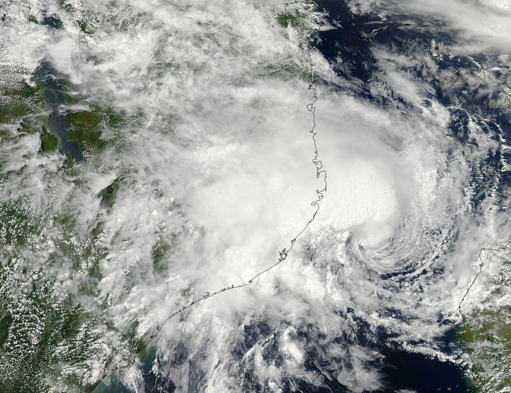
NASA's Aqua satellite captured this visible image of Tropical Cyclone 15S on March 5 at 11:25 UTC (6:25 a.m. EST) when it was hugging the coast of eastern Mozambique. Image Credit: NASA Goddard MODIS Rapid Response Team
The storm's lack of direction is short-lived, however, as forecasters at the Joint Typhoon Warning Center or JTWC expect that the storm will move in a southwesterly direction and landfall in west central Madagascar by March 9.
The Moderate Resolution Imaging Spectroradiometer or MODIS instrument that flies aboard NASA's Aqua satellite captured a visible image of Tropical Cyclone 15S on March 5 at 11:25 UTC (6:25 a.m. EST) when it was hugging the coast of eastern Mozambique.
The MODIS image showed that the bulk of clouds and rain were north and west of the center of circulation, extending over the Mozambique coastline, while the center of Tropical Cyclone 15S remained over the open waters of the Mozambique Channel.
On March 6 at 1500 UTC (10 a.m. EST), Tropical Cyclone 15S was centered near 16.5 south latitude and 41.3 east longitude, about 349 nautical miles (401 miles/464 km) north-northeast of Europa Island.
Maximum sustained winds were still near 35 knots (40 mph/62 kph), but are expected to increase over the next two days as it moves away from Mozambique and into the open waters of the Mozambique Channel, toward Madagascar. At 1500 UTC, however, it was moving slowly at 2 knots (2.3 mph/3.7 kph) to the west-northwest.
Tropical Cyclone 15S is expected to make landfall in west central Madagascar's Tsingy de Bemaraha Strict Nature Reserve and move across the island nation in a southeasterly direction, with its center expected to pass just south of the capital city of Antananarivo before exiting the east coast early next week.
Media Contact
All latest news from the category: Earth Sciences
Earth Sciences (also referred to as Geosciences), which deals with basic issues surrounding our planet, plays a vital role in the area of energy and raw materials supply.
Earth Sciences comprises subjects such as geology, geography, geological informatics, paleontology, mineralogy, petrography, crystallography, geophysics, geodesy, glaciology, cartography, photogrammetry, meteorology and seismology, early-warning systems, earthquake research and polar research.


Newest articles

High-energy-density aqueous battery based on halogen multi-electron transfer
Traditional non-aqueous lithium-ion batteries have a high energy density, but their safety is compromised due to the flammable organic electrolytes they utilize. Aqueous batteries use water as the solvent for…

First-ever combined heart pump and pig kidney transplant
…gives new hope to patient with terminal illness. Surgeons at NYU Langone Health performed the first-ever combined mechanical heart pump and gene-edited pig kidney transplant surgery in a 54-year-old woman…

Biophysics: Testing how well biomarkers work
LMU researchers have developed a method to determine how reliably target proteins can be labeled using super-resolution fluorescence microscopy. Modern microscopy techniques make it possible to examine the inner workings…

