NASA sees strong vertical wind shear battering a weaker winston
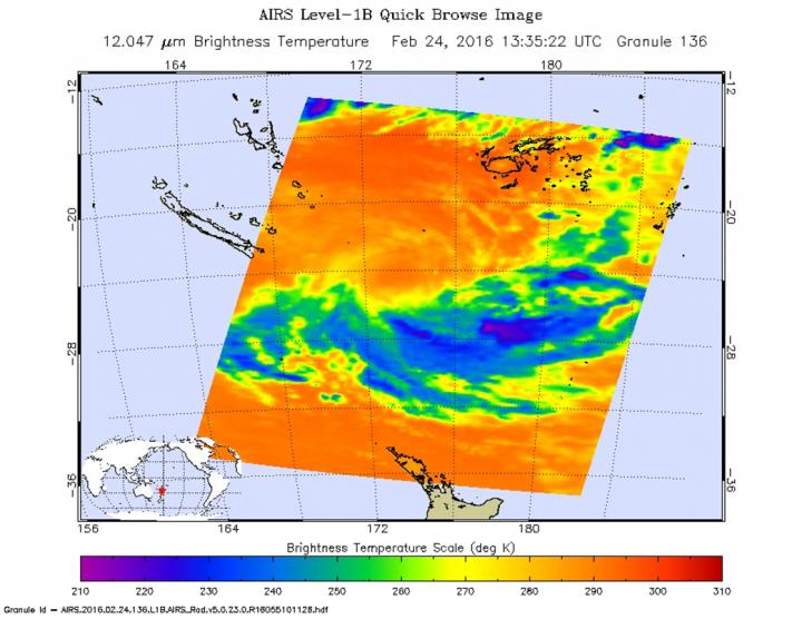
On Feb. 24, 2016, at 11:47 UTC (6:47 a.m. EST) the AIRS instrument aboard NASA's Aqua satellite saw a few strong storms remaining in Winston being pushed to the southeast because of strong vertical wind shear. Credits: NASA JPL/Ed Olsen
NASA's Aqua satellite passed over Winston and infrared data showed that the northerly wind shear had pushed the bulk of strongest storms to the south of the center.
The Joint Typhoon Warning Center upper-level analysis showed Winston had moved into an unfavorable environment with strong (30 to 40 knots/34.5 to 46 mph/55.5 to 74 kph) vertical wind shear.
At 1500 UTC (10 a.m. EST) on Feb. 24, 2016 Tropical cyclone Winston had weakened to a tropical storm. Maximum sustained winds were near 45 knots (51.7 mph/83.3 kph). It was centered near 24.5 degrees south latitude and 173.9 degrees east longitude, about 459 nautical miles (528.2 miles/850.1 km) south-southwest of Suva, Fiji. Winston was moving to the west at 9 knots (10.3 mph/16.6 kph).
The Atmospheric Infrared Sounder or AIRS instrument that flies aboard NASA's Aqua satellite measured temperatures in Tropical Storm Winston's cloud tops on Feb. 24, 2016 at 11:47 UTC (6:47 a.m. EST). AIRS saw a few strong storms remaining in the system, but they were pushed to the south because of strong vertical wind shear.
Thunderstorms in that quadrant had coldest cloud tops near minus 63 degrees Fahrenheit (minus 53 degrees Celsius). Cloud tops around the rest of the tropical storm were much warmer indicating they were lower in the atmosphere and less potent storms.
Winston is forecast to move to the south-southwest and stay far to the south of New Caledonia. As it moves, it is expected to weaken and become sub-tropical south of New Caledonia within the next day.
Media Contact
All latest news from the category: Earth Sciences
Earth Sciences (also referred to as Geosciences), which deals with basic issues surrounding our planet, plays a vital role in the area of energy and raw materials supply.
Earth Sciences comprises subjects such as geology, geography, geological informatics, paleontology, mineralogy, petrography, crystallography, geophysics, geodesy, glaciology, cartography, photogrammetry, meteorology and seismology, early-warning systems, earthquake research and polar research.


Newest articles

High-energy-density aqueous battery based on halogen multi-electron transfer
Traditional non-aqueous lithium-ion batteries have a high energy density, but their safety is compromised due to the flammable organic electrolytes they utilize. Aqueous batteries use water as the solvent for…

First-ever combined heart pump and pig kidney transplant
…gives new hope to patient with terminal illness. Surgeons at NYU Langone Health performed the first-ever combined mechanical heart pump and gene-edited pig kidney transplant surgery in a 54-year-old woman…

Biophysics: Testing how well biomarkers work
LMU researchers have developed a method to determine how reliably target proteins can be labeled using super-resolution fluorescence microscopy. Modern microscopy techniques make it possible to examine the inner workings…

