NASA Sees Giovanna Reach Cyclone Strength, Threaten Madagascar
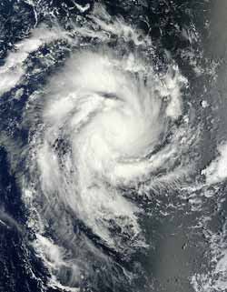
The MODIS instrument on NASA's Terra satellite captured this image at 06:00 UTC (1 a.m. EST) on February 10, 2012, as Tropical Cyclone Giovanna moved through the Southern Indian Ocean. Although the visible image did not reveal an eye, infrared data did see the beginning of an eye. The thunderstorms around the center of circulation are higher than the surrounding clouds, and cast shadow on the lower surrounding clouds in this image. Credit: NASA Goddard MODIS Rapid Response Team<br>
Now named Cyclone Giovanna, this storm has reached Category One status on the Saffir-Simpson Hurricane/Cyclone scale with maximum sustained winds near 65 knots (~75 mph/120.4 kph) on February 10, 2012. It was located about 480 nautical miles (552 miles/889 km) northeast of La Reunion island, near 15.8 South and 61.2 East. It was moving to the west-southwest near 8 knots (9mph/15 kph).
When NASA's Terra satellite passed over Cyclone Giovanna, the Moderate Resolution Imaging Spectroradiometer (MODIS) aboard, captured a visible image at 06:00 UTC (1 a.m. EST) on February 10, 2012. Although the visible image did not reveal an eye, infrared data from the Atmospheric Infrared Sounder (AIRS) instrument aboard NASA's Aqua satellite did see the beginning of an eye. In the visible image, the thunderstorms around the center of circulation appeared higher than the surrounding clouds, and cast shadow on the lower surrounding clouds.
Forecasters at the Joint Typhoon Warning Center (JTWC) are still forecasting a landfall in east-central Madagascar. Residents of Madagascar need to prepare for the storm's arrival and expect heavy, flooding rainfall, very rough surf conditions and Cyclone-force winds.
On February 10 at 0900 UTC (4 a.m. EST) the JTWC forecast stated: “Due to the favorable environment, Giovanna is forecast to strengthen to a peak of 110 knots (~127 mph/~204 kph) within the next 36 hours.” The system is expected to weaken significantly as it tracks across Madagascar; however, re-development is expected in the Mozambique Channel after 120 hours.”
Text Credit: Rob Gutro
NASA's Goddard Space Flight Center, Greenbelt, Md.
Media Contact
All latest news from the category: Earth Sciences
Earth Sciences (also referred to as Geosciences), which deals with basic issues surrounding our planet, plays a vital role in the area of energy and raw materials supply.
Earth Sciences comprises subjects such as geology, geography, geological informatics, paleontology, mineralogy, petrography, crystallography, geophysics, geodesy, glaciology, cartography, photogrammetry, meteorology and seismology, early-warning systems, earthquake research and polar research.


Newest articles

High-energy-density aqueous battery based on halogen multi-electron transfer
Traditional non-aqueous lithium-ion batteries have a high energy density, but their safety is compromised due to the flammable organic electrolytes they utilize. Aqueous batteries use water as the solvent for…

First-ever combined heart pump and pig kidney transplant
…gives new hope to patient with terminal illness. Surgeons at NYU Langone Health performed the first-ever combined mechanical heart pump and gene-edited pig kidney transplant surgery in a 54-year-old woman…

Biophysics: Testing how well biomarkers work
LMU researchers have developed a method to determine how reliably target proteins can be labeled using super-resolution fluorescence microscopy. Modern microscopy techniques make it possible to examine the inner workings…

