NASA sees formation of Tropical Storm Fernanda in Eastern Pacific Ocean
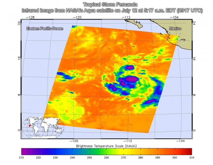
This infrared image of Tropical Depression 6E, later named Fernanda, was taken on July 12 at 5:17 a.m. EDT (0917 UTC) just to the south of southwestern Mexico. The purple areas indicate coldest cloud tops and strongest storms. Credit: NASA JPL/Ed Olsen
Tropical Depression 6E formed on July 11 at 11 p.m. EDT (July 12 at 0300 UTC) about 740 miles (1,190 km) south of the southern tip of Baja California, Mexico.
Infrared satellite imagery from the Atmospheric Infrared Sounder or AIRS instrument that flies aboard NASA's Aqua satellite taken on July 12 at 5:17 a.m. EDT (0917 UTC) provided a look at the temperatures of Tropical Depression 6E's clouds. That data was false colored and made into an image at NASA's Jet Propulsion Laboratory in Pasadena, California to highlight cloud top temperatures.
In infrared imagery, the coldest cloud tops indicate towering thunderstorms high into the troposphere. The colder the clouds, the stronger the storms.
AIRS data showed that some cloud tops around the center of circulation were as cold as minus 63 degrees Fahrenheit or minus 53 degrees Celsius. Cloud top temperatures that cold have been shown to generate heavy rainfall.
Less than six hours later, by 11 a.m. EDT (1500 UTC) on July 12, the National Hurricane Center (NHC) in Miami noted the depression strengthened into a tropical storm.
At that time, the center of Tropical Storm Fernanda was located near 12.0 degrees north latitude and 111.5 degrees west longitude. That's about 760 miles (1,225 km) south of the southern tip of Baja California, Mexico.
Fernanda was moving toward the west near 10 mph (17 kph) and the NHC expects this motion to continue with some increase in forward speed during the next couple of days. Maximum sustained winds have increased near 40 mph (65 kph) with higher gusts. Additional strengthening is expected during the next 48 hours.
Because Tropical Storm Fernanda is far from land, there are no coastal watches or warnings in effect.
For updated forecasts, visit the NHC website at: http://www.
Media Contact
All latest news from the category: Earth Sciences
Earth Sciences (also referred to as Geosciences), which deals with basic issues surrounding our planet, plays a vital role in the area of energy and raw materials supply.
Earth Sciences comprises subjects such as geology, geography, geological informatics, paleontology, mineralogy, petrography, crystallography, geophysics, geodesy, glaciology, cartography, photogrammetry, meteorology and seismology, early-warning systems, earthquake research and polar research.


Newest articles

High-energy-density aqueous battery based on halogen multi-electron transfer
Traditional non-aqueous lithium-ion batteries have a high energy density, but their safety is compromised due to the flammable organic electrolytes they utilize. Aqueous batteries use water as the solvent for…

First-ever combined heart pump and pig kidney transplant
…gives new hope to patient with terminal illness. Surgeons at NYU Langone Health performed the first-ever combined mechanical heart pump and gene-edited pig kidney transplant surgery in a 54-year-old woman…

Biophysics: Testing how well biomarkers work
LMU researchers have developed a method to determine how reliably target proteins can be labeled using super-resolution fluorescence microscopy. Modern microscopy techniques make it possible to examine the inner workings…

