NASA Sees Eastern Pacific's Second Tropical Storm Form
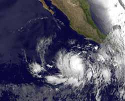
This infrared image from NASA's GOES-13 satellite shows newly developed Tropical Storm Bud off the southwestern coast of Mexico in the eastern Pacific. The image was taken at 1200 UTC (8 a.m. EDT/5 a.m. PDT) and shows a well-developed tropical storm. Baja California is seen in the top center part of the image.<br><br>Credit: Credit: NASA/NOAA GOES Project<br>
On May 21, NASA satellites were monitoring Tropical Depression 02E in the eastern Pacific Ocean, and 24 hours later it strengthened into the second tropical storm of the season. Tropical Storm Bud was captured by NOAA's GOES-13 satellite on May 22, and appears to be well-formed.
Tropical Storm Bud isn't going to stop there, however. According to the forecasters at the National Hurricane Center, Bud is expected to become a hurricane because of light to moderate wind shear and warm sea surface temperatures.
On May 22 at 0900 UTC (2 a.m. PDT/5 a.m. EDT), Tropical Storm Bud's maximum sustained winds were up to 40 mph (65 kph). Bud was centered about 515 miles (825 km) south of Zihuatenejo, Mexico, near 10.4 North and 103.0 West. Bud was moving to the west-northwest near 12 mph (19 kph).
An infrared satellite image of Tropical Storm Bud was captured from the Atmospheric Infrared Sounder (AIRS) instrument onboard NASA's Aqua satellite on May 22, and showed a large area of very strong thunderstorms located mostly to the west of the center of circulation. The infrared image depicts that area with very cold cloud top temperatures that exceed -63 Fahrenheit (-52 Celsius). Microwave satellite imagery indicates that Bud's center of circulation is near the eastern edge of the large area of convection and thunderstorms. That's an indication of the moderate wind shear blowing from the east and pushing those thunderstorms west of the center.
Forecasters at the National Hurricane Center expect that Bud may become a hurricane by Wednesday, May 23 and begin curving to the northeast and toward the mainland of Mexico. Residents of western Mexico need to watch the progress of this tropical cyclone.
Media Contact
More Information:
http://www.nasa.govAll latest news from the category: Earth Sciences
Earth Sciences (also referred to as Geosciences), which deals with basic issues surrounding our planet, plays a vital role in the area of energy and raw materials supply.
Earth Sciences comprises subjects such as geology, geography, geological informatics, paleontology, mineralogy, petrography, crystallography, geophysics, geodesy, glaciology, cartography, photogrammetry, meteorology and seismology, early-warning systems, earthquake research and polar research.


Newest articles

High-energy-density aqueous battery based on halogen multi-electron transfer
Traditional non-aqueous lithium-ion batteries have a high energy density, but their safety is compromised due to the flammable organic electrolytes they utilize. Aqueous batteries use water as the solvent for…

First-ever combined heart pump and pig kidney transplant
…gives new hope to patient with terminal illness. Surgeons at NYU Langone Health performed the first-ever combined mechanical heart pump and gene-edited pig kidney transplant surgery in a 54-year-old woman…

Biophysics: Testing how well biomarkers work
LMU researchers have developed a method to determine how reliably target proteins can be labeled using super-resolution fluorescence microscopy. Modern microscopy techniques make it possible to examine the inner workings…

