NASA Satellite Sees Tropical Storm Yagi Just South of Japan
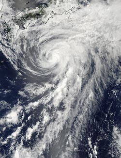
NASA’s Aqua satellite passed over Tropical Storm Yagi on Tuesday, June 11 at 1:10 p.m. Japan local time and captured this visible image that showed clouds associated with the northern fringes of the storm were draped over southeastern coastal Japan. Credit: NASA Goddard MODIS Rapid Response Team<br>
NASA’s Aqua satellite passed over Tropical Storm Yagi on Tuesday, June 11 at 04:10 UTC (12:10 a.m. EDT/1:10 p.m. Japan local time) and the Moderate Resolution Imaging Spectroradiometer or MODIS instrument captured a visible image of the storm. The image showed that clouds associated with the northern fringes of the storm were draped over southeastern coastal Japan.
The MODIS image also revealed that Yagi has a long “tail” or band of thunderstorms feeding into the center from the south.
Multispectral satellite imagery shows tight bands of thunderstorms wrapping into the center of the storm, although the building of thunderstorms continues to weaken around the center. Vertical wind shear is starting to take a toll on Yagi, according to the Joint Typhoon Warning Center. Northwesterly wind shear has made a slight tilt to the system with the upper-level center displaced about 20 nautical miles east of the low-level center. When the lower and upper level centers of circulation are not “stacked,” a tropical cyclone begins weakening.
At 09:00 UTC (5 a.m. EDT/6 p.m. Japan local time) Yagi had maximum sustained winds near 50 knots. Tropical storm force winds extend out 95 miles from the center, making the storm about 200 miles wide. Yagi was centered near 29.2 north and 136.9 east, about 307 miles west-northwest of Chichi Jima, Japan. Yagi was moving to the north-northeast at 17 knots. Yagi is kicking up seas with wave heights topping 21 feet, so the southeastern coast of Japan can expect rough seas until Yagi passes by.
Yagi is forecast to turn to the southeast and move away from Japan over the next couple of days, where it is expected to weaken and dissipate.
Text credit: Rob Gutro
NASA’s Goddard Space Flight Center
Media Contact
All latest news from the category: Earth Sciences
Earth Sciences (also referred to as Geosciences), which deals with basic issues surrounding our planet, plays a vital role in the area of energy and raw materials supply.
Earth Sciences comprises subjects such as geology, geography, geological informatics, paleontology, mineralogy, petrography, crystallography, geophysics, geodesy, glaciology, cartography, photogrammetry, meteorology and seismology, early-warning systems, earthquake research and polar research.


Newest articles

High-energy-density aqueous battery based on halogen multi-electron transfer
Traditional non-aqueous lithium-ion batteries have a high energy density, but their safety is compromised due to the flammable organic electrolytes they utilize. Aqueous batteries use water as the solvent for…

First-ever combined heart pump and pig kidney transplant
…gives new hope to patient with terminal illness. Surgeons at NYU Langone Health performed the first-ever combined mechanical heart pump and gene-edited pig kidney transplant surgery in a 54-year-old woman…

Biophysics: Testing how well biomarkers work
LMU researchers have developed a method to determine how reliably target proteins can be labeled using super-resolution fluorescence microscopy. Modern microscopy techniques make it possible to examine the inner workings…

