NASA satellite sees System 91S undeveloped in Mozambique Channel
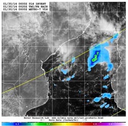
TRMM passed over System 91S on Jan. 30 at 0820 UTC/3:20 a.m. EST and captured rainfall data on the low. The heaviest rainfall rates were occurring over the waters of the Mozambique Channel (yellow/orange).<br><br>Credit: NASA/NRL/ESA<br>
At 800 UTC/3 a.m. EST, the center of System 91S was located near 18.2 south latitude and 39.1 east longitude, about 370 nautical miles northeast of Maputo, Mozambique (which is in the southernmost part of the country).
TRMM passed over System 91S on January 30 at 0820 UTC/3:20 a.m. EST and captured rainfall data on the low. The heaviest rainfall rates were occurring over the waters of the Mozambique Channel, where rain was falling in one area at about 1 inch/25 mm per hour.
Other rainfall from the system was light. The U.S. Naval Research Laboratory overlaid TRMM rainfall imagery on top of visible imagery from Europe's METEO-7 satellite to provide a full picture of the low. The center appeared to be in the western Channel, while the heaviest rainfall was occurring in the eastern Channel.
Animated multispectral satellite imagery shows that the low-level center is elongating as a result of wind shear. A ridge of high pressure located southwest of System 91S is creating moderate wind shear (20 to 25 knots/37.0 to 46.3 kph/23.0 to 28.7 mph) hampering development.
Forecasters at the Joint Typhoon Warning Center have dropped the chances for System 91S to a low chance for potential for tropical development in the next day or two.
Media Contact
More Information:
http://www.nasa.govAll latest news from the category: Earth Sciences
Earth Sciences (also referred to as Geosciences), which deals with basic issues surrounding our planet, plays a vital role in the area of energy and raw materials supply.
Earth Sciences comprises subjects such as geology, geography, geological informatics, paleontology, mineralogy, petrography, crystallography, geophysics, geodesy, glaciology, cartography, photogrammetry, meteorology and seismology, early-warning systems, earthquake research and polar research.


Newest articles

A universal framework for spatial biology
SpatialData is a freely accessible tool to unify and integrate data from different omics technologies accounting for spatial information, which can provide holistic insights into health and disease. Biological processes…

How complex biological processes arise
A $20 million grant from the U.S. National Science Foundation (NSF) will support the establishment and operation of the National Synthesis Center for Emergence in the Molecular and Cellular Sciences (NCEMS) at…

Airborne single-photon lidar system achieves high-resolution 3D imaging
Compact, low-power system opens doors for photon-efficient drone and satellite-based environmental monitoring and mapping. Researchers have developed a compact and lightweight single-photon airborne lidar system that can acquire high-resolution 3D…

