NASA's GPM observes Arkansas and Tennessee flooding downpours
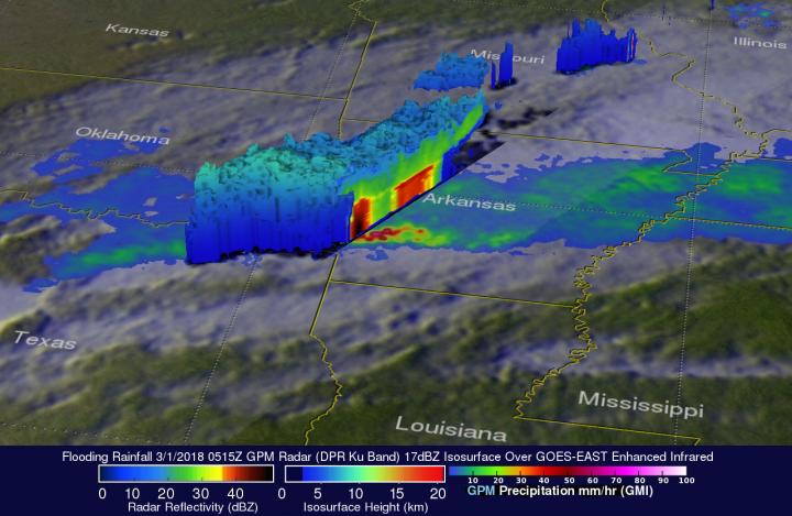
On Feb. 28, 2018 at 11:15 p.m. CST, GPM data was used to create 3-D views that showed intense storms extending from Oklahoma into southwestern Arkansas. Storm tops in the area were shown by GPM to reach heights above 5.6 miles (9 km). Credit: NASA / JAXA, Hal Pierce
NOAA's National Weather Service has issued flood advisories and flood warnings for large areas of Arkansas and Tennessee on March 1. Large parts of the Ohio Valley and Mississippi valley have received flooding rainfall during the past week. Arkansas has seen more rain than any other state.
Life threatening flood conditions have resulted from over 10 inches (254 mm) of rain falling in extensive areas of central Arkansas.
The GPM core observatory satellite had an excellent view of the storms that were producing flooding rainfall in Arkansas when it flew above the state on Wednesday February 28, 2018 at 11:15 p.m. CST (March 1 at 0515 UTC). A rainfall analysis was derived from data received by the satellite with GPM's microwave Imager (GMI) and Dual Frequency Precipitation Radar (DPR) instruments.
GPM's radar passed directly above storms that were dropping heavy rain over southwestern Arkansas. GPM's radar (DPR) indicated that some of these storms were dropping rain at greater than 5.1 inches (30.7 mm) per hour. GPM is a joint mission between NASA and the Japan Aerospace Exploration Agency, JAXA.
At NASA's Goddard Space Flight Center in Greenbelt, Md. the GPM satellite's 3-D radar data (DPR Ku Band) were used to show the vertical structure of precipitation falling over Arkansas. These 3-D views use GPM's radar data to reveal simulated cross-sections of intense storms that were extending from Oklahoma into southwestern Arkansas. Storm tops in the area were shown by GPM to reach heights above 5.6 miles (9 km).
On March 1, the National Weather Service in Little Rock, Arkansas noted “Much of central and southern Arkansas has seen between one and three inches, with isolated higher amounts, of rainfall over the last 24 hours. This has only aggravated the flooding situation across the area. Excessive runoff will continue today, even well after the rain ends.”
###
For updated warnings and watches in Arkansas, visit the National Weather Service web page: https:/
For more information about GPM, visit: http://www.
Media Contact
All latest news from the category: Earth Sciences
Earth Sciences (also referred to as Geosciences), which deals with basic issues surrounding our planet, plays a vital role in the area of energy and raw materials supply.
Earth Sciences comprises subjects such as geology, geography, geological informatics, paleontology, mineralogy, petrography, crystallography, geophysics, geodesy, glaciology, cartography, photogrammetry, meteorology and seismology, early-warning systems, earthquake research and polar research.


Newest articles

A universal framework for spatial biology
SpatialData is a freely accessible tool to unify and integrate data from different omics technologies accounting for spatial information, which can provide holistic insights into health and disease. Biological processes…

How complex biological processes arise
A $20 million grant from the U.S. National Science Foundation (NSF) will support the establishment and operation of the National Synthesis Center for Emergence in the Molecular and Cellular Sciences (NCEMS) at…

Airborne single-photon lidar system achieves high-resolution 3D imaging
Compact, low-power system opens doors for photon-efficient drone and satellite-based environmental monitoring and mapping. Researchers have developed a compact and lightweight single-photon airborne lidar system that can acquire high-resolution 3D…

