NASA keeping an eye on Dorian's remnants
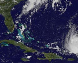
NOAA's GOES-13 satellite captured this image of Dorian's remnants (far right) located north of Puerto Rico on July 29 at 10:45 a.m. EDT.<br><br>Credit: NASA GOES Project<br>
NASA and NOAA satellites continue to keep a close eye on the remnants of Tropical Storm Dorian as they make their way through the eastern Caribbean Sea.
On Saturday, July 27 at 11 a.m. EDT, Dorian was still a tropical storm, but that didn't last. Dorian was near 18.5N and 52.1W, about 720 miles (1,160 km) east of the Northern Leeward Islands. Dorian's maximum sustained winds were near 40 mph (65 kph) and it was moving to the west at 23 mph (37 kph).
By July 28, Dorian weakened to a remnant low pressure area. It was producing showers and thunderstorms that extended a few hundred miles northeast of the Northern Leeward Islands. Dorian's remnants passed north of the Leeward Islands on July 28.
On Monday, July 29, remnants of Doran and a trough (elongated area) of low pressure were generating disorganized clouds and thunderstorms a couple of hundred miles north of Puerto Rico. Those clouds were seen by NOAA's GOES-13 satellite. The GOES-13 satellite image captured on July 29 at 14:45 UTC (10:45 a.m. EDT) shows that Dorian seems to have regained a more rounded appearance. However, the National Hurricane Center noted that the disturbance still does not appear to have a closed low-level circulation and surface pressures remain high across the area. If pressure drops, it would be a sign that the low pressure area is consolidating, but that was not occurring during the morning of July 29.
GOES satellites are managed and operated by NOAA, and the GOES image was created by NASA's GOES Project at the NASA Goddard Space Flight Center in Greenbelt, Md.
Environmental conditions are expected to be only marginally conducive for regeneration to occur, and the National Hurricane Center gives Dorian's remnants a medium chance, about 40 percent of becoming a tropical cyclone again. The remnant low is moving to the west and is expected to move to the west-northwest in the next two days. As it continues moving it is expected to move across the Turks and Caicos Islands and the Bahamas on Tuesday and Wednesday, July 30 and 31.
Media Contact
More Information:
http://www.nasa.govAll latest news from the category: Earth Sciences
Earth Sciences (also referred to as Geosciences), which deals with basic issues surrounding our planet, plays a vital role in the area of energy and raw materials supply.
Earth Sciences comprises subjects such as geology, geography, geological informatics, paleontology, mineralogy, petrography, crystallography, geophysics, geodesy, glaciology, cartography, photogrammetry, meteorology and seismology, early-warning systems, earthquake research and polar research.


Newest articles

Why getting in touch with our ‘gerbil brain’ could help machines listen better
Macquarie University researchers have debunked a 75-year-old theory about how humans determine where sounds are coming from, and it could unlock the secret to creating a next generation of more…

Attosecond core-level spectroscopy reveals real-time molecular dynamics
Chemical reactions are complex mechanisms. Many different dynamical processes are involved, affecting both the electrons and the nucleus of the present atoms. Very often the strongly coupled electron and nuclear…

Free-forming organelles help plants adapt to climate change
Scientists uncover how plants “see” shades of light, temperature. Plants’ ability to sense light and temperature, and their ability to adapt to climate change, hinges on free-forming structures in their…

