NASA analyzed the winds of Tropical Storm Ana
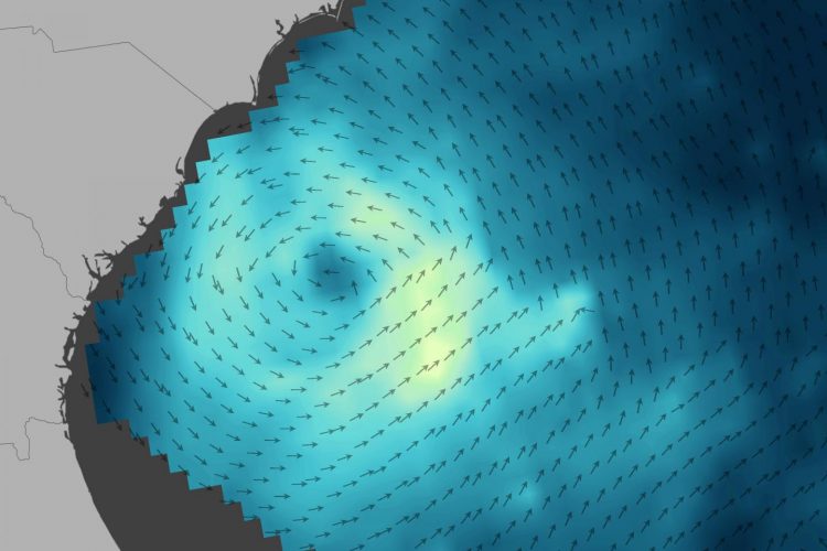
In this RapidScat wind data image from May 8, 2015 arrows represent the direction of near-surface winds. Shades of blue indicate the range of wind speeds (lighter blue and green represent faster-moving winds). Credits: NASA Earth Observatory/Joshua Stevens/JPL
Scientists took the opportunity to observe Ana's wind dynamics with the International Space Station-Rapid Scatterometer (ISS-RapidScat). The instrument, which joined NASA's Earth observing fleet in September 2015, measures ocean surface wind speed and direction from orbit on the International Space Station.
An image of Ana's winds was produced at NASA's Goddard Space Flight Center in Greenbelt, Maryland using data acquired by RapidScat as Ana approached the coast on the afternoon of May 8, 2015.
Arrows represent the direction of near-surface winds. Shades of blue indicate the range of wind speeds (lighter blue and green represent faster-moving winds).
RapidScat does not measure storms' wind speed and direction directly. Instead, microwave pulses from the instrument reflect off the ocean surface and back toward the sensor.
Rough waters–those disturbed more by wind–return a stronger signal than smooth waters. From that information, scientists can derive wind speed, as well as its direction based on the position of the waves.
The nature of this measurement method means that RapidScat is describing the winds close to the ocean's surface–useful information for weather forecasting and climate studies.
Higher up in a storm, winds can be even faster. At altitudes above about 500-1,000 meters (1,600-3,300 feet), winds no longer feel the effects of friction from the surface.
For more information: http://earthobservatory.
Media Contact
All latest news from the category: Earth Sciences
Earth Sciences (also referred to as Geosciences), which deals with basic issues surrounding our planet, plays a vital role in the area of energy and raw materials supply.
Earth Sciences comprises subjects such as geology, geography, geological informatics, paleontology, mineralogy, petrography, crystallography, geophysics, geodesy, glaciology, cartography, photogrammetry, meteorology and seismology, early-warning systems, earthquake research and polar research.


Newest articles

A universal framework for spatial biology
SpatialData is a freely accessible tool to unify and integrate data from different omics technologies accounting for spatial information, which can provide holistic insights into health and disease. Biological processes…

How complex biological processes arise
A $20 million grant from the U.S. National Science Foundation (NSF) will support the establishment and operation of the National Synthesis Center for Emergence in the Molecular and Cellular Sciences (NCEMS) at…

Airborne single-photon lidar system achieves high-resolution 3D imaging
Compact, low-power system opens doors for photon-efficient drone and satellite-based environmental monitoring and mapping. Researchers have developed a compact and lightweight single-photon airborne lidar system that can acquire high-resolution 3D…

