NASA's TRMM Satellite sees a small area of heavy rain left in Tropical Storm Hector
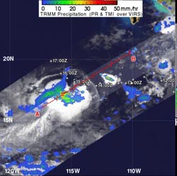
The TRMM satellite captured rainfall rates from Tropical Storm Hector on Aug. 14, 2012 1:28 a.m. EDT. TRMM data showed that Hector had a small area of moderate to heavy rainfall around the center of circulation. Heavy rainfall appears in red, falling at 2 inches/50 mm per hour. Light to moderate rainfall is depicted in blue and green (falling at a rate between .78 to 1.57 inches (20 to 40 mm) per hour.<br><br>Credit: Credit: SSAI/NASA, Hal Pierce<br>
The Tropical Rainfall Measuring Mission satellite known as TRMM is managed by both NASA and the Japanese Space Agency. From its orbit in space, TRMM's instruments can estimate rainfall from tropical cyclones.
The TRMM satellite captured rainfall rates from Tropical Storm Hector on August 14, 2012 1:28 a.m. EDT. TRMM data showed that Hector had a small area of moderate to heavy rainfall around the center of circulation. That small area of heavy rainfall was falling at 2 inches/50 mm per hour. For the most part, rainfall was light-to-moderate in other areas of Hector.
Hector is being battered by moderate winds from the east, and that has been pushing the rainfall to the west of the storm's center. That wind shear is expected to be around for the next couple of days, which will prevent Hector from strengthening.
On Tuesday, August 14 at 11 a.m. EDT (1500 UTC) Hector's maximum sustained winds remained near 45 mph (75 kmh). The center of Tropical Storm Hector was about 230 miles (365 km) west-southwest of Socorro Island and about 440 miles (710 km) southwest of the southern tip of Baja California. That puts Hector's center near latitude 18.1 north and longitude 114.4 west. Hector is moving toward the west near 6 mph (9 kmh).
Hector is moving west and is expected to turn northwest before weakening into a remnant low pressure area by the end of the week.
Media Contact
More Information:
http://www.nasa.govAll latest news from the category: Earth Sciences
Earth Sciences (also referred to as Geosciences), which deals with basic issues surrounding our planet, plays a vital role in the area of energy and raw materials supply.
Earth Sciences comprises subjects such as geology, geography, geological informatics, paleontology, mineralogy, petrography, crystallography, geophysics, geodesy, glaciology, cartography, photogrammetry, meteorology and seismology, early-warning systems, earthquake research and polar research.


Newest articles

High-energy-density aqueous battery based on halogen multi-electron transfer
Traditional non-aqueous lithium-ion batteries have a high energy density, but their safety is compromised due to the flammable organic electrolytes they utilize. Aqueous batteries use water as the solvent for…

First-ever combined heart pump and pig kidney transplant
…gives new hope to patient with terminal illness. Surgeons at NYU Langone Health performed the first-ever combined mechanical heart pump and gene-edited pig kidney transplant surgery in a 54-year-old woman…

Biophysics: Testing how well biomarkers work
LMU researchers have developed a method to determine how reliably target proteins can be labeled using super-resolution fluorescence microscopy. Modern microscopy techniques make it possible to examine the inner workings…

