Bermuda in warnings as the GOES-13 Satellite catches Fiona approaching
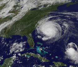
The GOES-13 satellite captured a visible image of Tropical Storm Fiona approaching Bermuda at 1825 UTC (2:25 p.m. EDT). The Category 4 Hurricane Earl nearing North Carolina\'s coast is located on the left (in the larger image), the much smaller Fiona is located on the lower right. Credit: NOAA/NASA Goes Project<br>
A tropical storm warning is in effect for Bermuda today, Sept. 2, as tropical storm force winds are expected there by late Friday. Bermuda can expect between 1 to 3 inches of rainfall from Fiona.
When the Geostationary Operational Environmental Satellite called GOES-13 captured a visible image of Tropical Storm Fiona approaching Bermuda this afternoon at 1825 UTC (2:25 p.m. EDT) it was a stark contrast in the size of two storms. The huge Category 4 Hurricane Earl nearing North Carolina's coast and is about 400 miles from end to end. Fiona appeared much smaller. Fiona's tropical storm force winds extend 115 miles from the center, although mainly to the east. If those winds were around the circumference of the storm, Fiona would be about 230 miles from end to end, but she's not even that large because most of the strong winds are on one side of the storm. By comparison, Earl dwarfs his “sister.”
GOES satellites are operated by NOAA, and the NASA GOES Project at NASA's Goddard Space Flight Center in Greenbelt, Md. produces satellite images and animations from them.
At 2 p.m. EDT on Sept. 2, Tropical Storm Fiona had maximum sustained winds near 50 mph, and slow weakening is forecast in the next 2 days. Fiona was about 520 miles south-southwest of Bermuda near 25.0 North and 66.3 West. She was moving north-northwest near 17 mph, with a minimum central pressure of 1002 millibars.
Media Contact
More Information:
http://www.nasa.govAll latest news from the category: Earth Sciences
Earth Sciences (also referred to as Geosciences), which deals with basic issues surrounding our planet, plays a vital role in the area of energy and raw materials supply.
Earth Sciences comprises subjects such as geology, geography, geological informatics, paleontology, mineralogy, petrography, crystallography, geophysics, geodesy, glaciology, cartography, photogrammetry, meteorology and seismology, early-warning systems, earthquake research and polar research.


Newest articles

High-energy-density aqueous battery based on halogen multi-electron transfer
Traditional non-aqueous lithium-ion batteries have a high energy density, but their safety is compromised due to the flammable organic electrolytes they utilize. Aqueous batteries use water as the solvent for…

First-ever combined heart pump and pig kidney transplant
…gives new hope to patient with terminal illness. Surgeons at NYU Langone Health performed the first-ever combined mechanical heart pump and gene-edited pig kidney transplant surgery in a 54-year-old woman…

Biophysics: Testing how well biomarkers work
LMU researchers have developed a method to determine how reliably target proteins can be labeled using super-resolution fluorescence microscopy. Modern microscopy techniques make it possible to examine the inner workings…

