An Infrared NASA Eye Sees a Weaker System 92B
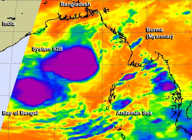
On May 22 at 19:29 UTC/3:29 p.m. EDT, NASA's Aqua satellite passed over System 92B and the AIRS instrument saw that the strong thunderstorms over the western quadrant had weakened. Image Credit: NASA JPL/Ed Olsen
On May 22 at 19:29 UTC/3:29 p.m. EDT, NASA's Aqua satellite passed over System 92B and infrared data from the Atmospheric Infrared Sounder (AIRS) instrument and the SSMIS instrument saw patchy deep convection flaring and dissipating over the western portion of a low-level circulation center. Earlier on May 22, the areas of strong thunderstorms were more persistent west of the center of circulation.
The Special Sensor Microwave Imager (SSM/I) and the Special Sensor Microwave Imager Sounder (SSMIS) are satellite passive microwave radiometers. This series of instruments has been carried onboard Defense Meteorological Satellite Program satellites since 1987.
The Joint Typhoon Warning Center (JTWC) noted that System 92B has weakened in response to persistent easterly vertical wind shear. The JTWC expects that wind shear to continue for another day.
On May 23 at 02:30 UTC (May 22 at 10:30 p.m. EDT), the center of System 92B was located near 16.2 north latitude and 91.0 east longitude, about 370 nautical miles south of Chittagong, Bangladesh. Maximum sustained winds are between 20 and 25 knots, and minimum central pressure is near 1002 millibars.
JTWC noted “based on the observed weakening trend and considering the potential for redevelopment if vertical wind shear relaxes over the next few days, the potential for the development of a significant tropical cyclone within the next 24 hours is downgraded to medium.”
Text credit: Rob Gutro
NASA's Goddard Space Flight Center
Media Contact
More Information:
http://www.nasa.gov/content/goddard/92b-northern-indian-ocean-may-2014/All latest news from the category: Earth Sciences
Earth Sciences (also referred to as Geosciences), which deals with basic issues surrounding our planet, plays a vital role in the area of energy and raw materials supply.
Earth Sciences comprises subjects such as geology, geography, geological informatics, paleontology, mineralogy, petrography, crystallography, geophysics, geodesy, glaciology, cartography, photogrammetry, meteorology and seismology, early-warning systems, earthquake research and polar research.


Newest articles

High-energy-density aqueous battery based on halogen multi-electron transfer
Traditional non-aqueous lithium-ion batteries have a high energy density, but their safety is compromised due to the flammable organic electrolytes they utilize. Aqueous batteries use water as the solvent for…

First-ever combined heart pump and pig kidney transplant
…gives new hope to patient with terminal illness. Surgeons at NYU Langone Health performed the first-ever combined mechanical heart pump and gene-edited pig kidney transplant surgery in a 54-year-old woman…

Biophysics: Testing how well biomarkers work
LMU researchers have developed a method to determine how reliably target proteins can be labeled using super-resolution fluorescence microscopy. Modern microscopy techniques make it possible to examine the inner workings…

