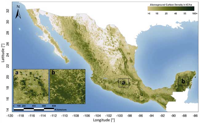
First Detailed Map of Aboveground Forest Carbon Stocks in Mexico Unveiled
Map Credit: Remote Sensing
The hectare-scale map is the result of a collaboration led by WHRC scientists Josef Kellndorfer and Oliver Cartus with Mexico’s National Forestry Commission (CONAFOR) and the Mexican Norway Project (MNP) to provide a tool for the national government to enhance a robust Measurement, Reporting and Verification (MRV) system for national carbon emissions.
“The release of this data set is an important step forward in the accounting for carbon flux in Mexico and in supporting efforts to reduce carbon emissions from the land sector,” says Dr. Kellndorfer. “We see the potential for these biomass data sets to be generated by other tropical nations.”
The map integrates Mexico’s National Forest Inventory (INFyS), which provides field measurements for 26,000 plots across Mexico with spatial image data from the Japanese ALOS PALSAR radar and U.S. Landsat satellite sensors, which contain complementary information on forest density and structure. The fusion of these three datasets allows for continuous estimates of carbon stocks where field data are missing even for those classes not very well represented in the national forest inventory. The team is currently testing airborne lidar data in a range of Mexico’s ecosystems as an option to augment field observations with airborne and satellite data to improve carbon mapping for countries without detailed forest inventories.
Rane Cortez from The Nature Conservancy, Chief of Party of the Allianza MREDD+ states, “Mexico is quickly becoming a leader on REDD+ and can serve as a model for other countries. This biomass map and dataset represent one of the important advancements that Mexico has made in developing its national monitoring system and will help the country prioritize its strategies and investments for reducing emissions from deforestation.”
This work was made possible by USAID within the framework of Mexico’s REDD+ project, the Gordon and Betty Moore Foundation, Google.org, and the David and Lucille Packard Foundation. Partners include CONAFOR, MNP, NASA, the University of Maryland, the National Commission for Knowledge and Use of Biodiversity (CANABIO), the U.S. Forest Service, The Nature Conservancy, Rainforest Alliance, and Natural Areas and Sustainable Development (ENDESU).
The maps and findings were published as “A National, Detailed Map of Forest Aboveground Carbon Stocks in Mexico” in the journal Remote Sensing.
For more information and to obtain data access, please visit http://whrc.org/mapping/pantropical/mexcarbon/mex_dataset.html
For further information on Allianza MREDD+ work in Mexico:
http://www.alianza-mredd.org/
WHRC is an independent research institute where scientists collaborate to examine the drivers and impacts of climate change and identify opportunities for conservation around the globe.
Contact: Eunice Youmans, Director of External Affairs 508-444-1509
Email Eunice Youmans
Media Contact
All latest news from the category: Ecology, The Environment and Conservation
This complex theme deals primarily with interactions between organisms and the environmental factors that impact them, but to a greater extent between individual inanimate environmental factors.
innovations-report offers informative reports and articles on topics such as climate protection, landscape conservation, ecological systems, wildlife and nature parks and ecosystem efficiency and balance.


Newest articles

A universal framework for spatial biology
SpatialData is a freely accessible tool to unify and integrate data from different omics technologies accounting for spatial information, which can provide holistic insights into health and disease. Biological processes…

How complex biological processes arise
A $20 million grant from the U.S. National Science Foundation (NSF) will support the establishment and operation of the National Synthesis Center for Emergence in the Molecular and Cellular Sciences (NCEMS) at…

Airborne single-photon lidar system achieves high-resolution 3D imaging
Compact, low-power system opens doors for photon-efficient drone and satellite-based environmental monitoring and mapping. Researchers have developed a compact and lightweight single-photon airborne lidar system that can acquire high-resolution 3D…

