Computers are quick and reliable in counting seals
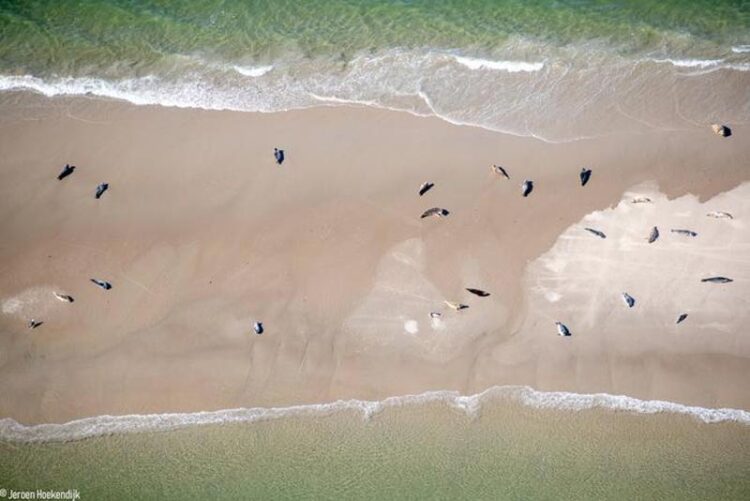
Aerial pictures of grey and harbour seals in the Dutch Wadden Sea. jeroen Hoekendijk
Picture: Jeroen Hoekendijk
Help from artificial intelligence (AI) in observing marine mammals is crucial.
Computers can count seals from aerial photographs with lightning speed and reliability. Based on their spatial patterns, the tiny dots on the aerial images can even be assigned to one of the two major species of seals in the Wadden Sea. That is shown in the thesis that marine biologist Jeroen Hoekendijk will defend on January 26 in Wageningen. “To better understand if and how marine mammals like seals are affected by climate change and the disappearance of sea ice, this help from artificial intelligence (AI) in observations is crucial,” Hoekendijk said. Hoekendijk carried out his research at the Royal Netherlands Institute for Sea Research and Wageningen University & Research.
Training AI with aerial photo’s
Harbor and grey seals in the Wadden Sea have long been counted using aerial photographs taken annually from a small aircraft. As a result, a large amount of aerial imagery is available with verified numbers of seals of both species. “We showed stacks of those old photos to a computer program and asked the computer, for example: ‘find the fifty grey seals we saw in this photo’. This allowed us to train the computer program in recognizing and counting seals,” Hoekendijk said.
Previously, computers were trained to count any objects by first manually marking each individual object on the images, which is a time-consuming task.
Spatial distribution
Grey and harbor seals also behave differently when lying on the sandbanks in the Wadden Sea. Harbor seals are clearly more dispersed than grey seals. “Based on that specific distribution pattern, we can now recognize and count species on images in which the resolution is too low to distinguish the species based on their external characteristics,” Hoekendijk said.
Wadden Sea field lab for big Arctic
The Wadden Sea has proven to be a perfect ‘field lab’ to develop these new methodologies, according to Hoekendijk. “We can now search for and count seals on a much larger scale in, for example, the Arctic. If you don’t know exactly where to look, then even looking for 7 million harp seals in the entire Arctic is like looking for needles in a haystack.”
Those counts of marine mammals like harp seals in the Arctic are essential, however, Hoekendijk argues. “With the disappearance of sea ice, it is expected that seals that rest, molt and give birth to their young on that ice, will have an increasingly hard time. To know the exact consequences, we will have to find and count the animals year by year”, Hoekendijk knows. The Arctic Ocean is expected to be completely ice-free possibly by the summer of 2035.
Satellite imagery
Hoekendijk expects that satellite imagery will play an increasingly important role in this work. “The resolution of satellite images is getting higher and higher. One pixel on a satellite photo measures only 31 by 31 cm nowadays. That means you can already see an individual seal from space. Added to that, ‘deep learning’ makes computers better and better at recognizing details. I expect that they are becoming indispensable in researching the consequences of climate change for marine mammals.”
All latest news from the category: Ecology, The Environment and Conservation
This complex theme deals primarily with interactions between organisms and the environmental factors that impact them, but to a greater extent between individual inanimate environmental factors.
innovations-report offers informative reports and articles on topics such as climate protection, landscape conservation, ecological systems, wildlife and nature parks and ecosystem efficiency and balance.


Newest articles

A blueprint for mapping melting ice sheets
Researchers in the Stanford Radio Glaciology lab use radio waves to understand rapidly changing ice sheets and their contributions to global sea-level rise. This technique has revealed groundwater beneath Greenland,…

Water hyacinth plant pots – utilization of an invasive species
Together with Fiber Engineering GmbH, the DITF presents a process for the production of biodegradable plant pots. The products are cost effective and competitive. At the same time, the production…

Current research on the new 6G mobile communications standard
Nursing care robots, autonomous driving, digital twins: all of these high-tech applications will play an essential role for the new 6G mobile communications standard. The first commercial 6G networks are…