Typhoon Rammasun made final landfall near China and Vietnam border
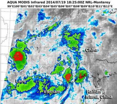
An infrared image on July 19 from the VIIRS instrument aboard NOAA-NASA's Suomi NPP satellite shows two areas of strong thunderstorms (red) in two areas near the Vietnam/China border. Credit: NRL/NOAA/NASA
NASA and NOAA's Suomi NPP satellite captured an infrared image the typhoon that showed strong thunderstorms with heavy rain potential.
Rammasun made landfall in southern China just north of the Vietnam border on July 18 at 8 p.m. EDT (July 19 at 0000 UTC). The Joint Typhoon Warning Center placed Rammasun's center near 21.9 north and 108.1 east, about 134 nautical miles (154.2 miles/248.2 km) east-northeast of Hanoi, Vietnam.
Maximum sustained winds were still near 100 knots (115.1. mph/185.2 kph) at the time of landfall. Rammasun was moving to the northwest at 15 knots (177.2 mph/27.7 kph) and was expected to dissipate over land in the next couple of days.
The China Meteorological Agency issued a red alert warning as Rammasun approached landfall on Saturday, July 19. A red alert is the highest level of warning.
When NASA-NOAA's Suomi NPP satellite passed over Rammasun on July 19 at 18:25 UTC (2:25 p.m. EDT) the Visible Infrared Imaging Radiometer Suite (VIIRS) instrument aboard captured an infrared image of the storm.
The VIIRS instrument showed three areas of powerful thunderstorms wrapping into the low-level center of circulation.
Two of those areas were along the Vietnam/China border and the other was over southwestern China, over Yun County, Yunnan, China, just north of the Laos border.
VIIRS collects visible and infrared imagery and global observations of land, atmosphere, cryosphere and oceans. VIIRS flies aboard the Suomi NPP satellite, which is managed by both NASA and NOAA.
Media Contact
More Information:
http://www.nasa.govAll latest news from the category: Earth Sciences
Earth Sciences (also referred to as Geosciences), which deals with basic issues surrounding our planet, plays a vital role in the area of energy and raw materials supply.
Earth Sciences comprises subjects such as geology, geography, geological informatics, paleontology, mineralogy, petrography, crystallography, geophysics, geodesy, glaciology, cartography, photogrammetry, meteorology and seismology, early-warning systems, earthquake research and polar research.


Newest articles

A universal framework for spatial biology
SpatialData is a freely accessible tool to unify and integrate data from different omics technologies accounting for spatial information, which can provide holistic insights into health and disease. Biological processes…

How complex biological processes arise
A $20 million grant from the U.S. National Science Foundation (NSF) will support the establishment and operation of the National Synthesis Center for Emergence in the Molecular and Cellular Sciences (NCEMS) at…

Airborne single-photon lidar system achieves high-resolution 3D imaging
Compact, low-power system opens doors for photon-efficient drone and satellite-based environmental monitoring and mapping. Researchers have developed a compact and lightweight single-photon airborne lidar system that can acquire high-resolution 3D…

