Tropical Depression Hagibis Gets a Second Chance
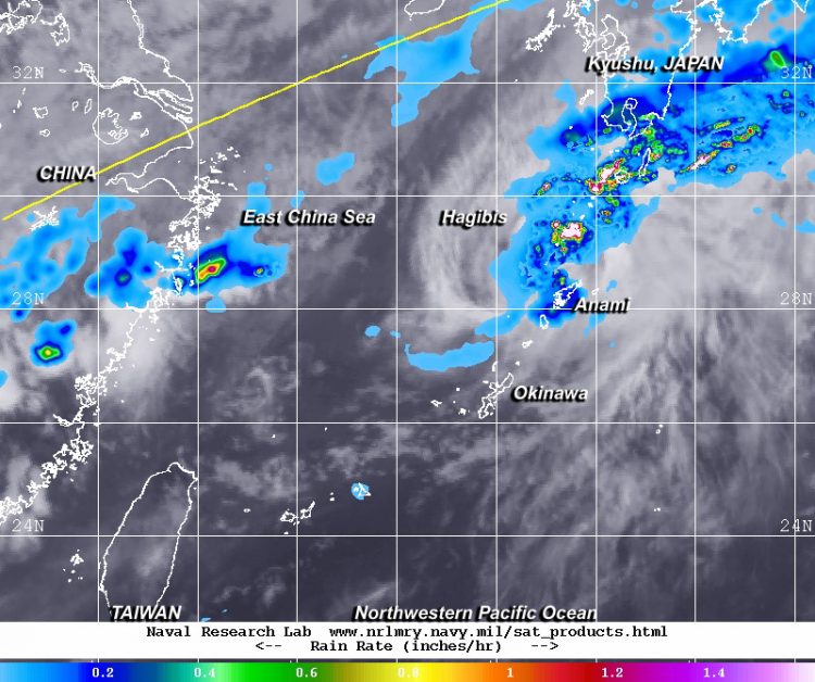
NASA's TRMM satellite showed moderate rainfall was occurring at a rate of 1.4 inches per hour in the northeastern quadrant of Tropical Depression Hagibis on June 17 in this composite image with MTSAT-2 satellite cloud data. Image Credit: NRL/NASA/ESA
On June 17 at 10:30 UTC (6:30 a.m. EDT) the Tropical Rainfall Measuring Mission or TRMM satellite passed over the regenerated Hagibis and the Precipitation Radar instrument gathered data on the storm's rainfall. The data showed that in the northeastern quadrant of the storm, moderate rainfall was occurring at a rate of 1.4 inches per hour. The TRMM satellite is managed by NASA and the Japanese Aerospace Exploration Agency.
Hagibis was speeding through the Northwestern Pacific Ocean and made it from southeastern China, past Taiwan and Andersen Air Base in one day.
On June 17 at 1500 UTC (11 a.m. EDT), Tropical Depression Hagibis' maximum sustained winds had increased up to 30 knots (34.5 mph/55.5 kph) and it was located about 200 nautical miles (230 miles/370 km) northeast of Kadena Air Base, Okinawa, Japan, near 29.6 north latitude and 131.9 east longitude. Hagibis was speeding to the east at 34 knots 39.1 mph/62.9 kph).
The Joint Typhoon Warning Center (JTWC) cited a report that Hagibis passed about 45 nautical miles north of Amami Island, where sustained winds less than 15 knots (17.2 mph/27.8 kph) were reported.
JTWC noted that Hagibis is being battered by vertical wind shear greater than 30 knots, which is elongating the storm. Hagibis has crossed the Kuroshio Current and is now over much cooler sea surface temperatures which will decrease convection (the ability to build the thunderstorms that make up a tropical cyclone).
The Kuroshio Current originates from Taiwan's east coast and flows in a northeasterly direction past Japan, where it joins the easterly movement of the North Pacific Current. The Kuroshio Current has been likened to the movement of the Gulf Stream along the U.S. east coast.
Hagibis is expected to continue on an east-northeasterly track, passing north of Iwo To and staying south of mainland Japan as it heads into the open waters of the Northwestern Pacific Ocean where it will transition into an extra-tropical cyclone in the next day.
Text credit: Rob Gutro
NASA's Goddard Space Flight Center
Media Contact
All latest news from the category: Earth Sciences
Earth Sciences (also referred to as Geosciences), which deals with basic issues surrounding our planet, plays a vital role in the area of energy and raw materials supply.
Earth Sciences comprises subjects such as geology, geography, geological informatics, paleontology, mineralogy, petrography, crystallography, geophysics, geodesy, glaciology, cartography, photogrammetry, meteorology and seismology, early-warning systems, earthquake research and polar research.


Newest articles

A universal framework for spatial biology
SpatialData is a freely accessible tool to unify and integrate data from different omics technologies accounting for spatial information, which can provide holistic insights into health and disease. Biological processes…

How complex biological processes arise
A $20 million grant from the U.S. National Science Foundation (NSF) will support the establishment and operation of the National Synthesis Center for Emergence in the Molecular and Cellular Sciences (NCEMS) at…

Airborne single-photon lidar system achieves high-resolution 3D imaging
Compact, low-power system opens doors for photon-efficient drone and satellite-based environmental monitoring and mapping. Researchers have developed a compact and lightweight single-photon airborne lidar system that can acquire high-resolution 3D…

