TRMM satellite peers at rainfall in developing low near Mozambique
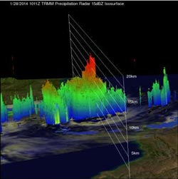
TRMM satellite flew above a tropical low (91S) in the Mozambique Channel on Jan. 28, 2014, at 1011 UTC and this 3-D view using TRMM PR data shows that some towering storms near the center of the low were reaching heights of above 16km (about 9.9 miles).<br><br>Credit: NASA/SSAI, Hal Pierce<br>
An analysis of rainfall from TRMM's Microwave Imager (TMI) and Precipitation Radar (PR) instruments are shown on the left overlaid on a visible/infrared image from TRMM's Visible and InfraRed Scanner (VIRS). TRMM PR measured rain falling at the rate of over 134.9 mm/~5.3 inches per hour in a band of powerful convective thunderstorms north of the center of circulation.
A 3-D view was created at NASA's Goddard Space Flight Center in Greenbelt, Md. using TRMM PR data. That image showed that some towering storms near the center of the low were reaching heights of above 16 km/9.9 miles. Towers this tall near the center of the tropical low are often an indication of tropical cyclone formation or intensification.
On January 29 at 1430 UTC/9:30 a.m. EST, the Joint Typhoon Warning Center dropped System 91S from formation alert status, but the low pressure area still has a medium chance for development in the next 24 hours. System 91S was located near 18.2 south and 39.1 east, about 585 nautical miles northeast of Maputo, Mozambique.
An image from India's Oceansat satellite indicated 20 to 25 knot (37.0 to 46.3 kph/23.0 to 28.7 mph winds over the eastern semi-circle of the storm. Meanwhile the NOAA-19 polar orbiting satellite data showed weak, shallow convective banding of thunderstorms wrapping into the low-level center on January 29.
System 91S is located in an environment with moderate vertical wind shear. The Joint Typhoon Warning Center noted that dynamic computer model guidance shows System 91S should weaken as it continues moving to the southwest.
Only one named tropical cyclone called Deliwe has passed through the Mozambique Channel so far this year but this analysis found that areas of the Mozambique Channel from southeastern Mozambique through western Madagascar have already had well above normal rainfall for the past 30 days.
Media Contact
More Information:
http://www.nasa.govAll latest news from the category: Earth Sciences
Earth Sciences (also referred to as Geosciences), which deals with basic issues surrounding our planet, plays a vital role in the area of energy and raw materials supply.
Earth Sciences comprises subjects such as geology, geography, geological informatics, paleontology, mineralogy, petrography, crystallography, geophysics, geodesy, glaciology, cartography, photogrammetry, meteorology and seismology, early-warning systems, earthquake research and polar research.


Newest articles

Webb captures top of iconic horsehead nebula in unprecedented detail
NASA’s James Webb Space Telescope has captured the sharpest infrared images to date of a zoomed-in portion of one of the most distinctive objects in our skies, the Horsehead Nebula….

Cost-effective, high-capacity, and cyclable lithium-ion battery cathodes
Charge-recharge cycling of lithium-superrich iron oxide, a cost-effective and high-capacity cathode for new-generation lithium-ion batteries, can be greatly improved by doping with readily available mineral elements. The energy capacity and…

Novel genetic plant regeneration approach
…without the application of phytohormones. Researchers develop a novel plant regeneration approach by modulating the expression of genes that control plant cell differentiation. For ages now, plants have been the…

