Satellite sees birth of Tropical Storm Felicia in Eastern Pacific Ocean
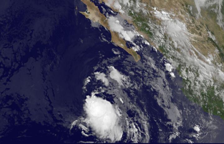
NOAA's GOES-West satellite captured an image of Tropical Storm Felicia on July 23 at 11:45 a.m. EDT showing a curved band of thunderstorms are wrapping around the southern quadrant of the storm. Credits: NASA/NOAA GOES Project
Previously known as tropical low pressure area “System 99E,” the storm finally developed after days of remaining unorganized. NOAA's GOES-West satellite captured an image of Tropical Storm Felicia on July 23, 2015 at 15:45 UTC (11:45 a.m. EDT). Satellite imagery shows that a curved band of thunderstorms are wrapping around the southern quadrant of the storm.
The low pressure area became Tropical Depression 7E at 5 a.m. EDT (0900 UTC) on July 23. By 11 a.m. EDT (1500 UTC) the depression strengthened into a tropical storm and was named Felicia. At that time, Felicia was located near latitude 19.1 North, longitude 114.9 West.
Felicia was moving toward the northwest near 13 mph (20 kph) and is forecast to turn to the west-northwest is forecast by Friday night, July 24. Maximum sustained winds were near 40 mph (65 kph).
The National Hurricane Center's forecaster Brennan noted that Tropical Storm Felicia doesn't seem to have much of a chance to develop much more as it's heading into cooler waters and moderate northerly vertical wind shear is expected to continue until it gets into those cooler waters.
The area it is headed toward are 26 Celsius (78.8 Fahrenheit), and tropical cyclones need sea surface temperatures of at least 26.6 Celsius (80 Fahrenheit) to maintain or increase intensity.
The National Hurricane Center expects Felicia to weaken late on July 24 and become a remnant low pressure area over the weekend of July 25 and 26.
Media Contact
All latest news from the category: Earth Sciences
Earth Sciences (also referred to as Geosciences), which deals with basic issues surrounding our planet, plays a vital role in the area of energy and raw materials supply.
Earth Sciences comprises subjects such as geology, geography, geological informatics, paleontology, mineralogy, petrography, crystallography, geophysics, geodesy, glaciology, cartography, photogrammetry, meteorology and seismology, early-warning systems, earthquake research and polar research.


Newest articles

A universal framework for spatial biology
SpatialData is a freely accessible tool to unify and integrate data from different omics technologies accounting for spatial information, which can provide holistic insights into health and disease. Biological processes…

How complex biological processes arise
A $20 million grant from the U.S. National Science Foundation (NSF) will support the establishment and operation of the National Synthesis Center for Emergence in the Molecular and Cellular Sciences (NCEMS) at…

Airborne single-photon lidar system achieves high-resolution 3D imaging
Compact, low-power system opens doors for photon-efficient drone and satellite-based environmental monitoring and mapping. Researchers have developed a compact and lightweight single-photon airborne lidar system that can acquire high-resolution 3D…

