Rosetta: OSIRIS’ view of Earth by night
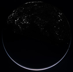
This is a composite of four images combined to show the illuminated crescent of Earth and the cities of the northern hemisphere. The images were acquired with the OSIRIS Wide Angle Camera (WAC) during Rosetta’s second Earth swing-by on 13 November. This image showing islands of light created by human habitation was taken with the OSIRIS WAC at 19:45 CET, about 2 hours before the closest approach of the spacecraft to Earth. At the time, Rosetta was about 80 000 km above the Indian Ocean where the local time approached midnight (the angle between Sun, Earth and Rosetta was about 160°). The image was taken with a five-second exposure of the WAC with the red filter. This image showing Earth’s illuminated crescent was taken with the WAC at 20:05 CET as Rosetta was about 75 000 km from Earth. The crescent seen is around Antarctica. The image is a colour composite combining images obtained at various wavelengths. Credits: ESA ©2005 MPS for OSIRIS Team MPS/UPD/LAM/IAA/RSSD/INTA/UPM/DASP/IDA
The images were acquired with the OSIRIS Wide Angle Camera (WAC) during Rosetta’s second Earth swing-by on 13 November.
This image showing islands of light created by human habitation was taken with the OSIRIS WAC at 19:45 CET, about 2 hours before the closest approach of the spacecraft to Earth.
At the time, Rosetta was about 80 000 km above the Indian Ocean where the local time approached midnight (the angle between Sun, Earth and Rosetta was about 160°). The image was taken with a five-second exposure of the WAC with the red filter.
This image showing Earth’s illuminated crescent was taken with the WAC at 20:05 CET as Rosetta was about 75 000 km from Earth.
The crescent seen is around Antarctica. The image is a colour composite combining images obtained at various wavelengths.
Media Contact
More Information:
http://www.esa.int/SPECIALS/Rosetta/SEM3HV53R8F_0.htmlAll latest news from the category: Earth Sciences
Earth Sciences (also referred to as Geosciences), which deals with basic issues surrounding our planet, plays a vital role in the area of energy and raw materials supply.
Earth Sciences comprises subjects such as geology, geography, geological informatics, paleontology, mineralogy, petrography, crystallography, geophysics, geodesy, glaciology, cartography, photogrammetry, meteorology and seismology, early-warning systems, earthquake research and polar research.


Newest articles

A universal framework for spatial biology
SpatialData is a freely accessible tool to unify and integrate data from different omics technologies accounting for spatial information, which can provide holistic insights into health and disease. Biological processes…

How complex biological processes arise
A $20 million grant from the U.S. National Science Foundation (NSF) will support the establishment and operation of the National Synthesis Center for Emergence in the Molecular and Cellular Sciences (NCEMS) at…

Airborne single-photon lidar system achieves high-resolution 3D imaging
Compact, low-power system opens doors for photon-efficient drone and satellite-based environmental monitoring and mapping. Researchers have developed a compact and lightweight single-photon airborne lidar system that can acquire high-resolution 3D…

