NASA Satellite Catches a Hurricane Transforming Itself
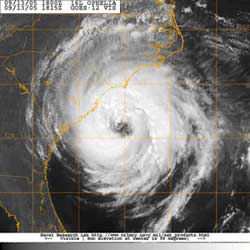
This is an image of Hurricane Ophelia (2005) from the Geostationary Operational Environmental Satellite (GOES)-12 during the storm’s warm-core tropical stages. Credit: Naval Research Laboratory, Marine Meteorology Division.
Hurricanes can completely re-structure themselves inside, and that presents forecasters with great uncertainty when predicting their effects on the general population.
Recently, scientists used data from NASA’s Tropical Rainfall Measuring Mission (TRMM) satellite to analyze transformations that take place inside a hurricane. Stephen Guimond, a graduate research assistant at Florida State University, Tallahassee, Fla., lead a study that used TRMM data to view the height at which ice melts near the core of several tropical cyclones (the generic name for hurricanes or tropical storms), including Hurricane Ophelia in 2005.
“The temperature structure of a tropical cyclone is directly related to a storm’s wind speed and rainfall, which indirectly affects the storm surge,” Guimond said. It is important to monitor a storm’s thermal structure because this information assists meteorologists in estimating the impact on threatened areas of high winds, flash flooding and large storm surge.
Many tropical cyclones transform into what are called “extra-tropical storms” as they move northward out of the tropics and into the mid-latitudes. During this stage, the storm’s cloud structure and high winds spread out over a wide area. As a result, the potential for heavy rainfall and large storm surge increases far from the center, potentially affecting life and property of more areas in the hurricane’s path.
When Guimond and his colleagues at the Naval Research Laboratory in Monterey, Calif. looked at the data from TRMM’s Precipitation Radar instrument, they could see the temperature changes inside a tropical cyclone. One piece of information that gave researchers a clue that a storm was becoming extra-tropical was that ice particles, which are found high up in the cold regions of thick clouds surrounding the eye of the storm, melted at lower levels. Usually, when a tropical cyclone is still in the “tropical stages,” ice particles melt higher in the clouds.
By analyzing when and where ice particles are melting in tropical cyclones, researchers can better understand the various stages of an extra-tropical storm. This knowledge will help scientists re-create storms on computer forecast models, which can assist in the forecasting of future tropical cyclone transformations.
There is another benefit to using the data from NASA’s TRMM radar. Guimond said that the thermal or heat data inferred from the satellite reveals information on storm intensity and also gives clues about how a storm formed. This will help hurricane forecasters and researchers gain a better sense of how the tropical cyclone will develop in the future.
These findings were presented at the American Meteorological Society’s 86th Annual Meeting in Atlanta.
Media Contact
All latest news from the category: Earth Sciences
Earth Sciences (also referred to as Geosciences), which deals with basic issues surrounding our planet, plays a vital role in the area of energy and raw materials supply.
Earth Sciences comprises subjects such as geology, geography, geological informatics, paleontology, mineralogy, petrography, crystallography, geophysics, geodesy, glaciology, cartography, photogrammetry, meteorology and seismology, early-warning systems, earthquake research and polar research.


Newest articles

A universal framework for spatial biology
SpatialData is a freely accessible tool to unify and integrate data from different omics technologies accounting for spatial information, which can provide holistic insights into health and disease. Biological processes…

How complex biological processes arise
A $20 million grant from the U.S. National Science Foundation (NSF) will support the establishment and operation of the National Synthesis Center for Emergence in the Molecular and Cellular Sciences (NCEMS) at…

Airborne single-photon lidar system achieves high-resolution 3D imaging
Compact, low-power system opens doors for photon-efficient drone and satellite-based environmental monitoring and mapping. Researchers have developed a compact and lightweight single-photon airborne lidar system that can acquire high-resolution 3D…

