Paleolake deposits on Mars might look like sediments in Indonesia
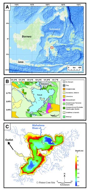
Figure 1. Lake Towuti, Indonesia. (A) Regional context for Lake Towuti on the island of Sulawesi in Indonesia. Red box indicates approximate location of part B. Background is the Ocean base map from ESRI et al. (2015). (B) Generalized geologic map of Lake Towuti and the surrounding area showing the dominance of ultramafic material. Map is modified from Costa et al. (2015). (C) Bathymetry of Lake Towuti showing the location of the two analyzed sediment cores at the distal margins of the Mahalona River delta (white dots labeled 4 for TOW4 and 5 for TOW5). River inputs are shown in thin blue lines, with the Mahalona River shown as a thick blue line. Credit: Goudge et al. and GSA Bulletin
In their GSA Bulletin article published online last week, Timothy A. Goudge and colleagues detail the clay mineralogy of sediment from Lake Towuti, Indonesia, using a technique called visible to near-infrared (VNIR) spectroscopy. VNIR measures the signature of reflected light from a sample across a larger wavelength range than just visible light. At Lake Towuti, the spectral record shows distinct variations in clay mineralogy over the past 40,000 years.
The record also captures the response of the lake system to changing climate, including changes in lake levels, forced delta progradation, and river incision. According to Goudge and colleagues, this demonstrates the utility of VNIR spectroscopy in developing paleoenvironmental records over tens of thousands of years.
Interestingly, Goudge and colleagues also suggest that paleolake deposits on Mars should preserve similar paleoenvironmental information that could be accessed through remote sensing studies of stratigraphy and VNIR reflectance spectroscopy.
Lead author Tim Goudge says, “The major link between this study of lake sediment in Indonesia and lake deposits on Mars is in terms of the methods we used. We can differentiate material properties with color (e.g., rust is red because of the iron in it), so VNIR spectroscopy allows us to determine what minerals are within a sample of lake sediment.”
While this technique is relatively new for applying to lake deposits on Earth, it can be run remotely simply using reflected sunlight. Thus it is commonly employed to study the mineralogy and composition of the surface of other planetary bodies, including Mars.
Goudge says, “Our study shows that one can use VNIR spectroscopy to understand the evolution of past climate that is recorded by lake sediment. Therefore, we propose that applying a similar approach to studying ancient lake deposits on Mars at high resolution will help to unravel the history of ancient martian climate.”
Lake Towuti is also contained within an ophiolite, which is composed of very iron- and magnesium-rich (mafic) rocks, and so is more comparable to the mafic surface of Mars than much of Earth's land surface, which is commonly more felsic (richer in silicon, aluminum, sodium, etc.). The compositional link is not perfect, however, so Goudge and colleagues more heavily emphasize the applicability of the technique.
###
FEATURED ARTICLE
A 40,000 yr record of clay mineralogy at Lake Towuti, Indonesia: Paleoclimate reconstruction from reflectance spectroscopy and perspectives on paleolakes on Mars Timothy A. Goudge, Post-doc Research Fellow, Jackson School of Geosciences, University of Texas at Austin, Austin, Texas 78712-1722, USA; James M. Russell, John F. Mustard, James W. Head and Satria Bijaksana.
GSA BULLETIN articles published ahead of print are online at http://gsabulletin.
Media Contact
All latest news from the category: Earth Sciences
Earth Sciences (also referred to as Geosciences), which deals with basic issues surrounding our planet, plays a vital role in the area of energy and raw materials supply.
Earth Sciences comprises subjects such as geology, geography, geological informatics, paleontology, mineralogy, petrography, crystallography, geophysics, geodesy, glaciology, cartography, photogrammetry, meteorology and seismology, early-warning systems, earthquake research and polar research.


Newest articles

Faster, more energy-efficient way to manufacture an industrially important chemical
Zirconium combined with silicon nitride enhances the conversion of propane — present in natural gas — needed to create in-demand plastic, polypropylene. Polypropylene is a common type of plastic found…

Energy planning in Ghana as a role model for the world
Improving the resilience of energy systems in the Global South. What criteria should we use to better plan for resilient energy systems? How do socio-economic, technical and climate change related…

Artificial blood vessels could improve heart bypass outcomes
Artificial blood vessels could improve heart bypass outcomes. 3D-printed blood vessels, which closely mimic the properties of human veins, could transform the treatment of cardiovascular diseases. Strong, flexible, gel-like tubes…

