NASA sees Typhoon Haikui approaching China in visible and infrared light
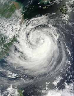
The MODIS instrument onboard NASA's Terra satellite captured this visible image of Typhoon Haikui as it nears landfall in China. This image was captured on Aug. 6, 2012, at 0220 UTC and shows Haikui's western edges brushing eastern China.<br><br>Credit: NASA Goddard MODIS Rapid Response Team<br>
NASA's Aqua satellite passed over Typhoon Haikui on August 5. The AIRS instrument captured an infrared image of the cloud temperatures that showed the strongest storms and heaviest rainfall in all quadrants of the storm except the northern area.
The strongest storms had cloud top temperatures near or exceeding -63 Fahrenheit (-52 Celsius). In an image captured on August 5 at 0441 UTC (12:41 a.m. EDT), those strong storms were seen over Okinawa, Japan. On August 6, 2012 at 0220 UTC NASA's Terra satellite captured a visible image of Haikui. It showed the western edge of the storm brushing mainland China.
On August 6 at 0900 UTC (5 a.m. EDT), the center of Haikui was northeast of Ishigakijima, Okinawa, Japan. Ishigakijima is the Okinawa Prefecture's third largest island and is Japan's southernmost city island. Haikui is also about 220 nautical miles (253 miles/407 km) northeast of Taipei, Taiwan. The storm is moving to the west-southwest at 5 knots (5.7 mph/9.2 kmh). Its maximum sustained winds were near 65 knots (75 mph/120 kmh).
Haikui is expected to make landfall south of Shanghai early on August 8.
High-resolution MODIS image available at: http://lance-modis.eosdis.nasa.gov/cgi-bin/imagery/single.cgi?image=Haikui.A2012219.0220.2km.jpg
Media Contact
More Information:
http://www.nasa.govAll latest news from the category: Earth Sciences
Earth Sciences (also referred to as Geosciences), which deals with basic issues surrounding our planet, plays a vital role in the area of energy and raw materials supply.
Earth Sciences comprises subjects such as geology, geography, geological informatics, paleontology, mineralogy, petrography, crystallography, geophysics, geodesy, glaciology, cartography, photogrammetry, meteorology and seismology, early-warning systems, earthquake research and polar research.


Newest articles

A universal framework for spatial biology
SpatialData is a freely accessible tool to unify and integrate data from different omics technologies accounting for spatial information, which can provide holistic insights into health and disease. Biological processes…

How complex biological processes arise
A $20 million grant from the U.S. National Science Foundation (NSF) will support the establishment and operation of the National Synthesis Center for Emergence in the Molecular and Cellular Sciences (NCEMS) at…

Airborne single-photon lidar system achieves high-resolution 3D imaging
Compact, low-power system opens doors for photon-efficient drone and satellite-based environmental monitoring and mapping. Researchers have developed a compact and lightweight single-photon airborne lidar system that can acquire high-resolution 3D…

