NASA Sees Tropical Storm Nanmadol's Landfall, Talas Headed to Japan
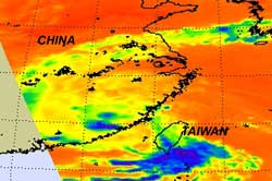
AIRS infrared image captured on Aug. 31 at 1:05 EDT, shows Nanmadol was dissipating quickly over mainland China with the lack of high, thunderstorm clouds (blue). Most of the remnants of Nanmadol are lower, warmer clouds (green). Credit: NASA/JPL, Ed Olsen <br>
Infrared satellite imagery from The Atmospheric Sounder Instrument (AIRS) aboard NASA's Aqua satellite shows two different stories in the tropical cyclones.
AIRS captured an infrared image of Nanmadol on Aug. 31 at 1:05 EDT dissipating quickly over mainland China with a lack of high, thunderstorm clouds. Most of the remnants of Nanmadol are lower, warmer clouds.
Tropical Storm Nanmadol made landfall about 2.00 a.m. local time on Aug. 31 (2 p.m. EDT on Aug. 30), in Jinjiang city, located in the Fujian Province, (southeastern) China. Nanmadol was a tropical storm at the time of landfall with sustained winds reported near 44 mph (72 kmh). By 8 a.m. local time/China on August 31 (August 30 at 8 p.m. EDT), Nanmadol's maximum sustained winds dropped down to 25 knots (29 mph/46 kmh), and it continued to move inland at 4 knots (5 mph/7 kmh). It was located near 24.9 North and 118.7 East. It is expected to dissipate later today or tomorrow.
Agence France-Press reported that Nanmadol destroyed hundreds of homes in Taiwan earlier this week.
AIRS infrared imagery of Tropical Storm Talas late on Aug. 30 (11:29 p.m. EDT) showed the large eastern half contained strong, high, thunderstorm clouds around the center where cloud top temperatures exceed -63F (-52C).
Today, Tropical Storm Talas is still working toward a landfall. The Joint Typhoon Warning Center forecasts a landfall in southern Japan on September 2. Talas still had maximum sustained winds near 55 knots (63 mph/103 kmh), as it did yesterday.
It was located about 465 miles (748 km) south of Kyoto, Japan, near 27.3 North and 136.8 East. It was moving to the northwest at 5 knots (6 mph/XXX). Talas is still a large storm with tropical storm-force winds extending out 210 miles, making it at least 420 miles (675 km) in diameter. Talas continues to intensify as it moves northward. Talas is expected to make landfall Friday and then become extra-tropical after crossing Japan and moving into the Sea of Japan.
Text Credit: Rob Gutro, NASA's Goddard Space Flight Center, Greenbelt, Md.
Media Contact
All latest news from the category: Earth Sciences
Earth Sciences (also referred to as Geosciences), which deals with basic issues surrounding our planet, plays a vital role in the area of energy and raw materials supply.
Earth Sciences comprises subjects such as geology, geography, geological informatics, paleontology, mineralogy, petrography, crystallography, geophysics, geodesy, glaciology, cartography, photogrammetry, meteorology and seismology, early-warning systems, earthquake research and polar research.


Newest articles

Webb captures top of iconic horsehead nebula in unprecedented detail
NASA’s James Webb Space Telescope has captured the sharpest infrared images to date of a zoomed-in portion of one of the most distinctive objects in our skies, the Horsehead Nebula….

Cost-effective, high-capacity, and cyclable lithium-ion battery cathodes
Charge-recharge cycling of lithium-superrich iron oxide, a cost-effective and high-capacity cathode for new-generation lithium-ion batteries, can be greatly improved by doping with readily available mineral elements. The energy capacity and…

Novel genetic plant regeneration approach
…without the application of phytohormones. Researchers develop a novel plant regeneration approach by modulating the expression of genes that control plant cell differentiation. For ages now, plants have been the…

